

 Merino Park
41° 49.242' N 71° 27.317' W See this location in: Google Maps Map Server Acme Maps
This is a site for launching hand-carried boats such as canoes or kayaks.
Description & Overview:

This is an informal access point at a city park in an low-income, urban neighborhood, so do not expect wilderness and do not leave valuables in your car. That said, the river in this area can be surprisingly beautiful. Trees overhang the river and sections of quickwater and whitewater provide interesting paddling challenges. Great Blue Herons and other wildlife are common. In low water the river in this area will be very rocky. In high water the paddling can be challenging whitewater that should only be attempted by experienced paddlers!
There used to be a gate to the park that was frequently closed. This gate has been removed.
This site provides access to the following water bodies in the Woonasquatucket River watershed: Woonasquatucket River.
Location:
Town: Providence
Nearest Town Center: Olneyville
Driving Landmarks: Merino Park is located behind (to the north of) the Hartford Park Housing complex. The entrance road to the park is an extension of Heath St. and parallels Route 6. If you are coming from downtown Providence, get off at the Route 6A exit, turn left at the light at the end of the ramp and go under Route 6 and then take the first right (after the exit ramp) onto Heath St. If you are coming from Johnston, take the Route 6A exit and turn left at the light at the end of the ramp and then take an immediate left onto Heath St. It will look like you are turning into the housing project but if you keep going Heath St. will take you into the park, where there is a large parking area.
Access & Waters:
Water 'Features' At Site: whitewater, flatwater/slow moving river
Note: Because one boat launch can access, say, both a lake and a river or both the upstream and downstream portions of a river, not all paddling trips at a given site will necessarily encounter all of the features listed.
Type of Access: Boat launch for hand carried boats
ADA Accessible Boat Launch? no
Shoreline: The shoreline is a tangle of tree roots that provide good footing for getting in and out of a canoe. Be careful where you step because some roots are not as solid as they look.
Float/Dock: no
Approximate Length of Carry between Car Access and Water: 450 feet
Hours of Operation: Sunrise to sunset, year-round (may not be plowed in winter)
Parking:
Parking: yes: 125 spaces, no overnight parking
ADA Accessible Parking Spaces? no
Sources for More Information:
AMC River Guide: 4th Edition, page 145
Ecological, Cultural & Recreational Attractions:
This area has been a park for generations. Many years ago there was a swimming and skating pond here.
Photographs:

Merino Park
Photography by: Bruce G. Hooke
Date of Photograph: October 11, 2007
This is a view of Merino Park from the parking lot. The best area to launch canoes and kayaks is across the soccer field and just into the trees, directly beyond the blue garbage can in the foreground of this photograph.
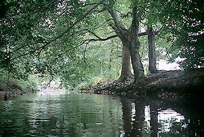
Merino Park Canoe Launch
Photography by: Bruce G. Hooke
Date of Photograph: October 11, 2007
This is a view of the best area in Merino Park for launching canoes and kayaks. This is just downstream of the sharp bend in the river, looking downstream.
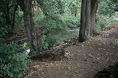
Merino Park Canoe Launch from Land
Photography by: Bruce G. Hooke
Date of Photograph: October 11, 2007
This is a view from land of the area shown from the water side in the previous photograph.
Do you have comments, corrections or additions to the information about this site?
Help us work together to make this website better by sharing your knowledge!

Private feedback goes to the Blueways Alliance/RI Land Trust Council. We'll use your information to make this website better or pass it along to the people who can deal with physical issues at this site. Public comments are posted here (once they've been reviewed and approved) for all to see.
The data on this website come from many sources, including volunteers and organizations across the state of Rhode Island and nearby parts of Massachusetts. We have done our best to make sure the data are accurate and up to date, but any information critical to the success of your trip should be confirmed before you start. The maps and information on this website should not be substituted for nautical charts, topographic maps, or other more detailed maps and guides. We welcome corrections and additions. To send a correction or provide other feedback, please use our feedback form (see link above).
This site report was last updated on January 15, 2009