

 Billington Cove
41° 25.354' N 71° 30.185' W See this location in: Google Maps Map Server Acme Maps
This is a site for launching boats from trailers. Boat ramps can normally be used to launch canoes and kayaks but please do your best to keep the boat ramp clear for boat trailers.
Description & Overview:

This town boat ramp, at the end of Pond Street, provides access to Point Judith Pond south of the busy "upper pond" area. However, since the only parking at the site is the paid parking at the marina, this boat ramp is of limited utility to the public.
Once on the water it is a short paddle from here to numerous rock islands, "the Hummocks," and "Whaley's Pots." Throughout Point Judith Pond there are many coves to poke into in a kayak or other small boat. The boat traffic in the pond can be busy in the summer, especially along the channel, in the mooring area at the north end of the pond, and most especially at the south end of the pond where the Block Island Ferry and other commercial traffic keeps things busy on the water year round.
On most days the southwest wind fills in across this area in the morning and blows throughout the afternoon, so be prepared for this when planning your trip.
This site provides access to the following water bodies in the Coastal Watersheds (West Bay) watershed: Point Judith Pond.
Location:
Alternate Site Name: Pond Street
Town: South Kingstown
Nearest Town Center: Wakefield
Driving Landmarks: Take the Pond Street exit off Route 1 in Wakefield. Head south on Pond Street (that means making a left turn at the end of the exit ramp if you were on Route 1 south and a right turn if you were on Route 1 north). Go about 1/2 mile and look for the ramp on your right next to the Billington Cove Marina. The only available parking is paid parking at the Marina.
Access & Waters:
Water 'Features' At Site: estuary
Note: Because one boat launch can access, say, both a lake and a river or both the upstream and downstream portions of a river, not all paddling trips at a given site will necessarily encounter all of the features listed.
Type of Access: Boat ramp
ADA Accessible Boat Launch? no
Shoreline: Hard surface boat ramp
Float/Dock: low float or dock
Hours of Operation: 24 hours/day, 7 days/week
Parking:
Parking: no
Sources for More Information:
Other Guidebooks: Salt Ponds Coalition Kayaker's Guide
Website: Salt Ponds Coalition Kayaker's Guide to the Coastal Salt Ponds of South County, RI
Website: Mike Krabach's kayak access website
Photographs:
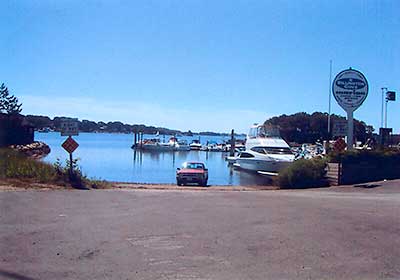
Billington Cove Boat Ramp
Photography by: Art Ganz and Bambi Poppick
Date of Photograph: August 17, 2006
Do you have comments, corrections or additions to the information about this site?
Help us work together to make this website better by sharing your knowledge!

Private feedback goes to the Blueways Alliance/RI Land Trust Council. We'll use your information to make this website better or pass it along to the people who can deal with physical issues at this site. Public comments are posted here (once they've been reviewed and approved) for all to see.
The data on this website come from many sources, including volunteers and organizations across the state of Rhode Island and nearby parts of Massachusetts. We have done our best to make sure the data are accurate and up to date, but any information critical to the success of your trip should be confirmed before you start. The maps and information on this website should not be substituted for nautical charts, topographic maps, or other more detailed maps and guides. We welcome corrections and additions. To send a correction or provide other feedback, please use our feedback form (see link above).
This site report was last updated on February 5, 2015