

 Vaughan Street Bridge
41° 51.588' N 70° 55.014' W See this location in: Google Maps Map Server Acme Maps
This is a site for launching hand-carried boats such as canoes or kayaks.
Description & Overview:

Vaughan Street is the first put-in on the Nemasket River below Assawompset Pond. Assawompset is a public water supply and so is closed to boating but the Nemasket is open to boating and is a wonderfully clean river that winds its way through wetlands and forests to its junction with the Taunton River above Titicut Street, 11 miles downriver from Vaughan Street.
The put-in at Vaughan Street is on the downriver side of the bridge down a short path from the new dirt parking lot. Just below the put-in the river forks. You can take either fork. The right fork takes you on a winding journey through a broad, open wetland. The left fork, an old steamboat channel, is more direct but may be brushy, especially in high summer. The two forks rejoin in about 1/2 mile (via the more winding route) and then the Nemasket continues to wind its way slowly through a lovely open wetland, a great place to look for birds and other wildlife.
Warning 1: As of June 2019, the main channel below Vaughn Street was filled with floating vegetation (probably milfoil, an invasive species) down to the start of the old steamboat channel, making it hard to paddle. Taking short, shallow strokes with your paddle will help but it will still be a hassle. See the photo below to get a sense of what it looks like.
Warning 2: The old steamboat channel has LOTS of poison ivy along both sides. As of June 2019 it was possible to paddle this route without touching the poison ivy, as long as you are careful, but if you have children on board warn them not to touch the vegetation. See the photos below to get a sense of what it looks like.
About 1.3 miles below the put-in you will come to the Bridge Street bridge over the Nemasket and shortly below that on the left is the put-in/take-out at Old Bridge Street. Below Old Bridge Street the river continues to be slow moving for another 2 miles to the take-out/portage at Wareham Street, below which the river becomes significantly faster and includes a bit of quickwater and whitewater before flattening out and slowing down again. For more details on this part of the river see the descriptions for Old Bridge Street and the put-ins below Old Bridge Street.
Click here for a printable map and guide (in Adobe Acrobat format) to paddling this part of the Nemasket River.
This site provides access to the following water bodies in the Taunton River watershed: Nemasket River.
Location:
Town: Lakeville
Nearest Town Center: Lakeville
Driving Landmarks: From I-495 north or south take the Exit 4 for Route 105, Middleboro Center and Lakeville. If you are coming from the north go right at the end of the ramp. If you are coming from the south go left at the end of the ramp. This will put you on South Main Street (Route 105) heading southwest. Go about a mile and turn left on Vaughan Street. Go 1.1 miles on Vaughan Street and look for a dirt parking lot on the left just before the bridge over the river.
Access & Waters:
Water 'Features' At Site: flatwater/slow moving river
Note: Because one boat launch can access, say, both a lake and a river or both the upstream and downstream portions of a river, not all paddling trips at a given site will necessarily encounter all of the features listed.
Type of Access: Boat launch for hand carried boats
ADA Accessible Boat Launch? no
Shoreline: At higher river levels the shoreline at the put-in can be a little muddy. At lower water levels it is sandier and some rock rip-rap may be exposed.
Float/Dock: no
Approximate Length of Carry between Car Access and Water: 60 feet
Parking:
Parking: yes: 8 spaces
ADA Accessible Parking Spaces? no
Nearby Amenities:
Public Restrooms: No
Sources for More Information:
AMC River Guide: 4th Edition, page 157
Website: Map and Guide to paddling the upper Nemsket River (Adobe Acrobat format)
Photographs:
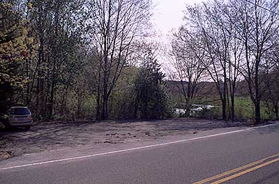
View of the parking area at Vaughn Street
Photography by: Bruce G. Hooke
Date of Photograph: May 1, 2010
The parking area at Vaughn Street. The river is visible through the trees to the right.
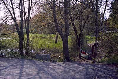
The Path to the River at Vaughn Street
Photography by: Bruce G. Hooke
Date of Photograph: May 1, 2010
The canoe in the picture is on the path to the river. This photograph was made in the spring when the river was high and had partly flooded the path to the river.
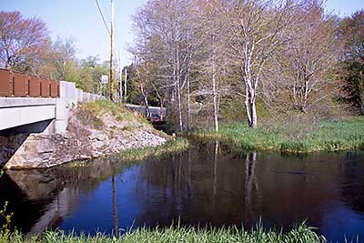
View of the Put-in at Vaughn Street from across the River
Photography by: Bruce G. Hooke
Date of Photograph: May 1, 2010
A view back across the river at the Vaughn Street put-in. Downriver is to the right in this picture.
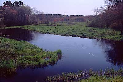
View Downriver from the Vaughn Street Bridge
Photography by: Bruce G. Hooke
Date of Photograph: May 1, 2010
This photograph was made in the spring when the river was high. The put-in at Vaughn Street is the channel leading to left in the foreground of this photograph. At lower water levels what is water there now would be dry land next to the river.
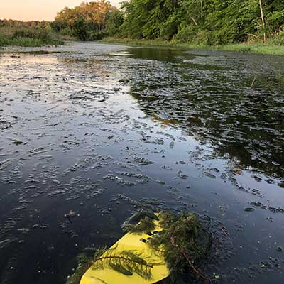
The Vegetation Clogging the Channel Below Vaughn Street
Photography by: Jen O'Keefe
Date of Photograph: June 24, 2019
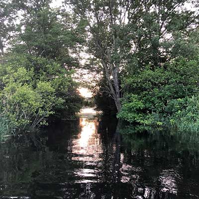
The Old Steamboat Channel
Photography by: Jen O'Keefe
Date of Photograph: June 24, 2019
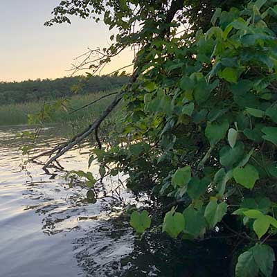
The Poison Ivy Along the Old Steamboat Channel
Photography by: Jen O'Keefe
Date of Photograph: June 24, 2019
Do you have comments, corrections or additions to the information about this site?
Help us work together to make this website better by sharing your knowledge!

Private feedback goes to the Blueways Alliance/RI Land Trust Council. We'll use your information to make this website better or pass it along to the people who can deal with physical issues at this site. Public comments are posted here (once they've been reviewed and approved) for all to see.
The data on this website come from many sources, including volunteers and organizations across the state of Rhode Island and nearby parts of Massachusetts. We have done our best to make sure the data are accurate and up to date, but any information critical to the success of your trip should be confirmed before you start. The maps and information on this website should not be substituted for nautical charts, topographic maps, or other more detailed maps and guides. We welcome corrections and additions. To send a correction or provide other feedback, please use our feedback form (see link above).
This site report was last updated on June 28, 2019