

 Reynolds Landing
42° 0.777' N 70° 59.573' W See this location in: Google Maps Map Server Acme Maps
This is a site for launching hand-carried boats such as canoes or kayaks.
Description & Overview:

Reynolds Landing, "dedicated to the memory of George I Reynolds," provides good access to the Town River below West Bridgewater for hand-carried boats. The Landing is in the middle of a pretty section of the Town River, where it winds through an open wetland with abundant bird life. The river throughout this area is very slow moving.
There is a short, level path leading from the parking area through the woods to a short side channel off the main river. Coming from the parking lot, follow the path that starts next to the white "regulations" sign. The shoreline at the landing can be a bit muddy.
Coming downriver to Reynolds Landing from West Bridgewater it is easy to miss the side channel leading to the landing. It is on the right on the outside of a left bend in the river and by the time you can see up it to the landing it is almost behind you. Once you can see up the side channel it is easy to tell that it is the right place because you can see the dirt path leading to the water.
From Reynolds Landing you can go either upriver or downriver. Going upriver will take you towards West Bridgewater. If the river is low you should have no problem getting to MA 28, 1.2 miles above Reynolds Landing. Going downriver you can go 1.2 miles downriver to High Street before turning around and returning to Reynolds Landing. Since there is a dam just below High Street there is basically no current as you get closer to High Street.
The river is effectively closed at High Street. Without trespassing on private property there is no place to take out above the High Street bridge. At most river levels the High Street Bridge is too low to fit under in a canoe or kayak and if you do manage to fit under the bridge, you will immediately come to a dam with no good portage around it. If you do manage to get past this dam, the next 2 miles of river is littered with garbage and blocked with numerous blow-downs. The next viable access to the river is 3.4 miles downriver at Hayward Street.
This site provides access to the following water bodies in the Taunton River watershed: Town River.
Location:
Alternate Site Name: Ash Street
Town: West Bridgewater
Nearest Town Center: West Bridgewater and Bridgewater Center
Driving Landmarks: From Route 24 north or south take Exit 16A for MA 106 East - W Bridgewater. This will put you on MA 106 (West Center Street) heading east. Go 2 miles and at the five-way intersection in the center of West Bridgewater, bear right onto MA 28. Go 0.4 miles on MA 28 (South Main Street) and turn left onto Ash Street. Go 0.6 miles east and south on Ash Street and look for a gravel drive on the left with a wooden sign for "Reynolds Landing."
Access & Waters:
Water 'Features' At Site: flatwater/slow moving river
Note: Because one boat launch can access, say, both a lake and a river or both the upstream and downstream portions of a river, not all paddling trips at a given site will necessarily encounter all of the features listed.
Type of Access: Boat launch for hand carried boats
ADA Accessible Boat Launch? no
Shoreline: Mud and some grass
Float/Dock: no
Approximate Length of Carry between Car Access and Water: 200 feet
Hours of Operation: closed at dusk
Parking:
Parking: yes: 8 spaces
ADA Accessible Parking Spaces? no
Nearby Amenities:
Public Restrooms: No
Sources for More Information:
AMC River Guide: 4th Edition, page 155
Photographs:
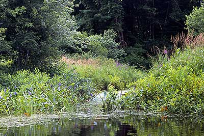
The Side Channel Leading to Reynolds Landing
Photography by: Bruce G. Hooke
Date of Photograph: July 15, 2010
Looking back up the side channel that leads to Reynolds Landing.
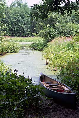
Renolds Landing
Photography by: Bruce G. Hooke
Date of Photograph: July 15, 2010
The side channel leading to Reynolds Landing is short. The water in the middle distance in this photograph is the main river channel.
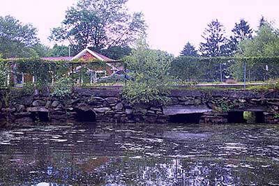
The High Street Bridge
Photography by: Bruce G. Hooke
Date of Photograph: July 15, 2010
Looking downriver at the High Street bridge, just over a mile downriver from Reynolds Landing. At this water level it might be just possible to squeeze under the bridge in a canoe but there is little point because just downriver from the bridge is a dam that is hard to get past and below the dam the river is blocked by many downed trees all the way through Bridgewater.
Do you have comments, corrections or additions to the information about this site?
Help us work together to make this website better by sharing your knowledge!

Private feedback goes to the Blueways Alliance/RI Land Trust Council. We'll use your information to make this website better or pass it along to the people who can deal with physical issues at this site. Public comments are posted here (once they've been reviewed and approved) for all to see.
The data on this website come from many sources, including volunteers and organizations across the state of Rhode Island and nearby parts of Massachusetts. We have done our best to make sure the data are accurate and up to date, but any information critical to the success of your trip should be confirmed before you start. The maps and information on this website should not be substituted for nautical charts, topographic maps, or other more detailed maps and guides. We welcome corrections and additions. To send a correction or provide other feedback, please use our feedback form (see link above).
This site report was last updated on July 28, 2010