


 Murdock Street Bridge
41° 56.019' N 70° 55.399' W See this location in: Google Maps Map Server Acme Maps
This is a site for launching hand-carried boats and it is also a portage. This typically means that to continue paddling down the river past this site you will have to portage your boat around a dam or other obstruction.
Description & Overview:

At very high river levels the bridge at Murdock Street will have to be portaged because there will not be enough space to fit under the bridge, but at most river levels canoes and kayaks can fit under the bridge. Murdock Street can also be used as the starting or ending point for a trip on the Nemasket but the very limited parking and poor visibility on the road means this is not the best place to put-in or take-out.
Be careful when walking on Murdock Street as the visibility for cars coming around the corner is not great and the cars tend to be going fast.
If portaging, take out on the right side of the river just before the bridge and carry across the road to the put-in on the same side of the river below the bridge. If you are taking out here and if you can fit under the bridge, the take-out below the bridge is a little better than the take-out above the bridge. Both are a little steep and rocky but quite usable.
Below the Murdock Street Bridge the Nemasket starts winding more and more as it gets closer to the Taunton. As of June 2011 there was reportedly a large tree down across the Nemasket below the Murdoch Street Bridge that forces a portage or "lift-over."
Aside from a power line corridor that crosses the river four times and a railroad bridge, signs of civilization are few as the river makes it way through woods and wetlands to its junction with the Taunton River, 2.7 miles downriver from the Murdock Street Bridge. At the junction with the Taunton turn left (downriver) and in a mile you will come to the Titicut Street Bridge where you can take out (or continue downriver). The better take-out at Titicut Street is below the bridge on the left side of the river but getting to this take-out means running some Class I rapids under the bridge.
This site provides access to the following water bodies in the Taunton River watershed: Nemasket River.
Location:
Town: Middleborough
Nearest Town Center: Middleborough and Bridgewater
Driving Landmarks: From Summer Street, go 400 feet west on Murdock Street.
Access & Waters:
Water 'Features' At Site: flatwater/slow moving river
Note: Because one boat launch can access, say, both a lake and a river or both the upstream and downstream portions of a river, not all paddling trips at a given site will necessarily encounter all of the features listed.
Type of Access: Boat launch for hand carried boats
ADA Accessible Boat Launch? no
Shoreline: Rocks, earth and roots
Float/Dock: no
Approximate Length of Carry between Car Access and Water: 100 feet
Portage Length: 75 feet
Parking:
Parking: on street, 1 spaces, no overnight parking
ADA Accessible Parking Spaces? no
Nearby Amenities:
Public Restrooms: No
Sources for More Information:
AMC River Guide: 4th Edition, pages 157-158
Photographs:
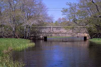
Looking Downriver at the Murdock Street Bridge
Photography by: Bruce G. Hooke
Date of Photograph: May 1, 2010
The Murdock Street Bridge at relatively high water levels in the spring. At this water level it is possible to fit under the bridge in a canoe or kayak. At higher river levels a portage would be necessary. The take-out for a portage is on the right before the bridge and the put-in below the bridge is also on the right.
The Take-Out above the Murdock Street Bridge
Photography by: Bruce G. Hooke
Date of Photograph: May 1, 2010
The take-out on the upriver side of the Murdock Street Bridge, with the river beyond.
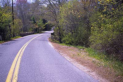
Murdock Street
Photography by: Bruce G. Hooke
Date of Photograph: May 1, 2010
This view of Murdock Street shows why this is not the best place to start or end a paddling trip. The very limited parking is on the right in this photo, and the better access to the river is down the bank on the same side of the road, just before whitish posts just visible in this photo before the bridge.
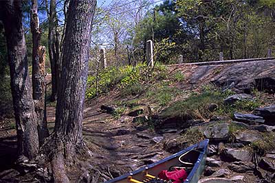
The Put-in Below the Murdock Street Bridge
Photography by: Bruce G. Hooke
Date of Photograph: May 1, 2010
The path to the put-in on the downriver side of the Murdock Street Bridge, on river right (the right side of the river facing downriver).
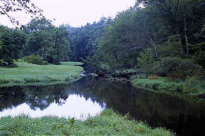
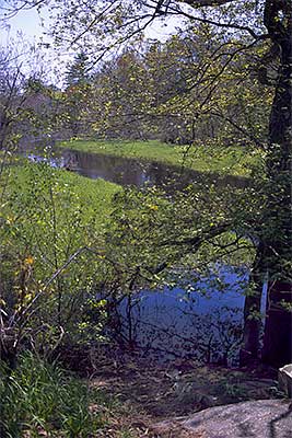
View Downriver from the Murdock Street Bridge
Photography by: Bruce G. Hooke
Date of Photograph: July 15, 2010
Do you have comments, corrections or additions to the information about this site?
Help us work together to make this website better by sharing your knowledge!

Private feedback goes to the Blueways Alliance/RI Land Trust Council. We'll use your information to make this website better or pass it along to the people who can deal with physical issues at this site. Public comments are posted here (once they've been reviewed and approved) for all to see.
The data on this website come from many sources, including volunteers and organizations across the state of Rhode Island and nearby parts of Massachusetts. We have done our best to make sure the data are accurate and up to date, but any information critical to the success of your trip should be confirmed before you start. The maps and information on this website should not be substituted for nautical charts, topographic maps, or other more detailed maps and guides. We welcome corrections and additions. To send a correction or provide other feedback, please use our feedback form (see link above).
This site report was last updated on June 16, 2011