

 Power Sub-Station Portage
42° 11.46' N 71° 44.857' W See this location in: Google Maps Map Server Acme Maps
This site is a portage. This typically means there either is no road access to this location or that the site is not recommended as a launching site for some other reason. The portage may be around a dam, whitewater, or some other obstruction.
Description & Overview:

The Power Sub-Station Dam must be portaged. The start of the portage is marked but use caution because the take-out for the portage is not far above the dam so errors made in landing could easily end with you or your boat being carried over the dam, especially if the river is high. There is a large sign on river left warning about the dam and just beyond it is a smaller sign marking the start of the portage trail. The portage trail is somewhat rough and the last section down to the river is steep. The trail is not marked but is fairly wide and clear. There is plenty of poison ivy in the area.
If the river is low you can carry right over the rocks at the left end of the dam, avoiding the portage trail.
Below the dam there is a short section of quickwater and then the river slows down again.
For paddling this section of the Blackstone a more detailed guide is necessary then this website can provide. You should use the AMC River Guide or a similar book and only paddle this section of the river if you are an experienced paddler.
This site provides access to the following water bodies in the Blackstone River watershed: Blackstone River.
Location:
Town: Millbury
Access & Waters:
Water 'Features' At Site: dam, whitewater, flatwater/slow moving river
Note: Because one boat launch can access, say, both a lake and a river or both the upstream and downstream portions of a river, not all paddling trips at a given site will necessarily encounter all of the features listed.
Type of Access: Portage
ADA Accessible Boat Launch? no
Shoreline: Grassy bank (somewhat high) above the dam, gravel shoreline below the dam.
Float/Dock: no
Parking:
Parking: no
Sources for More Information:
AMC River Guide: 4th edition pages 150-151
Photographs:
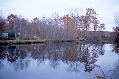
Approaching the Dam from the Upstream Side
Photography by: Bruce Hooke
Date of Photograph: November 3, 2008
This view shows the start of the portage trail around the dam. The larger sign at the left edge of the picture warns about the dam ahead and the smaller sign to the right of it marks the start of the portage trail around the dam. The dam is on the right side of the picture and as you can see from this picture the dam is not very visible from upstream.
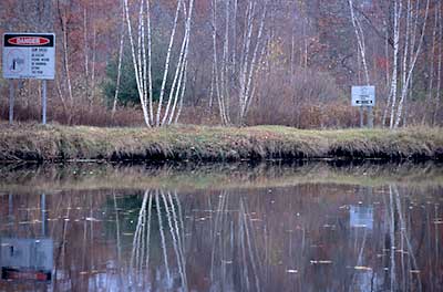
Detail of Start of Portage
Photography by: Bruce Hooke
Date of Photograph: November 3, 2008
This view provides a closer look at the take out at the start of the portage around the dam.
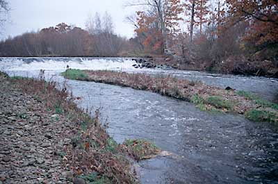
The Dam and the River below the Dam
Photography by: Bruce Hooke
Date of Photograph: November 3, 2008
This view shows the dam and the river below the dam. After a short section of quickwater the river slows down again.
Do you have comments, corrections or additions to the information about this site?
Help us work together to make this website better by sharing your knowledge!

Private feedback goes to the Blueways Alliance/RI Land Trust Council. We'll use your information to make this website better or pass it along to the people who can deal with physical issues at this site. Public comments are posted here (once they've been reviewed and approved) for all to see.
The data on this website come from many sources, including volunteers and organizations across the state of Rhode Island and nearby parts of Massachusetts. We have done our best to make sure the data are accurate and up to date, but any information critical to the success of your trip should be confirmed before you start. The maps and information on this website should not be substituted for nautical charts, topographic maps, or other more detailed maps and guides. We welcome corrections and additions. To send a correction or provide other feedback, please use our feedback form (see link above).
This site report was last updated on July 26, 2010