

 Plymouth Street Bridge
41° 55.31' N 70° 55.4' W See this location in: Google Maps Map Server Acme Maps
This site is a portage. This typically means there either is no road access to this location or that the site is not recommended as a launching site for some other reason. The portage may be around a dam, whitewater, or some other obstruction.
Description & Overview:

Unless the river is fairly low the old bridge at Plymouth Street will have to be portaged. At low river levels it is possible to squeeze under the bridge if you are careful (and don't mind a short but dark tunnel). Otherwise, take out on the right side of the river above the bridge and carry across the bridge to put in down the concrete steps on the left side of the river below the bridge.
The Plymouth Street Bridge is closed to vehicle traffic but there is vehicle access to either end of the bridge so this site could be used as a put-in or take-out. However, because this is a quiet residential neighborhood without good parking it is not recommended as a put-in or take-out except in an emergency.
Please be respectful of the private property owners along the river. The take-out above the bridge in particular is on the edge of someone's front yard so be neat, quiet, and courteous, and don't spend more time than you need to here so that the paddlers who come after you will continue to be welcome here.
Below Plymouth Street the Nemasket continues to wind quietly through woods and marshes to its junction the Taunton River. At higher river levels you will have to portage around the Murdock Street Bridge 1.1 miles downriver from the Plymouth Street bridge.
This site provides access to the following water bodies in the Taunton River watershed: Nemasket River.
Location:
Town: Middleborough
Nearest Town Center: Middleborough
Access & Waters:
Water 'Features' At Site: flatwater/slow moving river
Note: Because one boat launch can access, say, both a lake and a river or both the upstream and downstream portions of a river, not all paddling trips at a given site will necessarily encounter all of the features listed.
Type of Access: Portage
ADA Accessible Boat Launch? no
Shoreline: Grass and earth above the bridge, concrete steps below the bridge.
Float/Dock: no
Portage Length: 125 feet
Parking:
Parking: on street
ADA Accessible Parking Spaces? no
Nearby Amenities:
Public Restrooms: No
Sources for More Information:
AMC River Guide: 4th Edition, pages 157-158
Photographs:
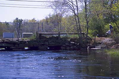
Looking Upriver at the Decrepit Plymouth Street Bridge
Photography by: Bruce G. Hooke
Date of Photograph: May 1, 2010
This photograph shows why a portage is necessary at the Plymouth Street Bridge when the river is high, as it is in this photograph. The put-in below the bridge is the concrete steps on the right side of this photograph.
Do you have comments, corrections or additions to the information about this site?
Help us work together to make this website better by sharing your knowledge!

Private feedback goes to the Blueways Alliance/RI Land Trust Council. We'll use your information to make this website better or pass it along to the people who can deal with physical issues at this site. Public comments are posted here (once they've been reviewed and approved) for all to see.
The data on this website come from many sources, including volunteers and organizations across the state of Rhode Island and nearby parts of Massachusetts. We have done our best to make sure the data are accurate and up to date, but any information critical to the success of your trip should be confirmed before you start. The maps and information on this website should not be substituted for nautical charts, topographic maps, or other more detailed maps and guides. We welcome corrections and additions. To send a correction or provide other feedback, please use our feedback form (see link above).
This site report was last updated on August 29, 2010