

 Gooseberry Road Town Ramp
41° 23.148' N 71° 31.165' W See this location in: Google Maps Map Server Acme Maps
This is a site for launching boats from trailers. Boat ramps can normally be used to launch canoes and kayaks but please do your best to keep the boat ramp clear for boat trailers.
Description & Overview:
This public access site has an asphalt boat ramp in good condition but there is no public parking. Paid parking may be available at nearby marinas. There are a number of other nearby boat ramps that do have parking.
This boat ramp is on the channel connecting Point Judith and Potter Ponds so paddlers can access either pond. However, the tidal current in this channel is very strong and heavy boat traffic should also be expected. On most days the southwest wind fills in across this area in the morning and blows throughout the afternoon, so be prepared for this when planning your trip.
This site provides access to the following water bodies in the Coastal Watersheds (West Bay) watershed: Point Judith Pond.
Location:
Town: South Kingstown
Nearest Town Center: Wakefield
Driving Landmarks: From Route 1 take Succotash Road south 0.6 miles to Gooseberry Road. Turn left on Gooseberry Road. The town boat ramp is at the end of Gooseberry Road, next to Channel Marina.
Access & Waters:
Water 'Features' At Site: estuary
Note: Because one boat launch can access, say, both a lake and a river or both the upstream and downstream portions of a river, not all paddling trips at a given site will necessarily encounter all of the features listed.
Type of Access: Boat ramp
ADA Accessible Boat Launch? no
Shoreline: Asphalt boat ramp
Float/Dock: no
Hours of Operation: 24/7, year-round
Parking:
Parking: no
Nearby Amenities:
Public Restrooms: No
Sources for More Information:
Other Guidebooks: Salt Ponds Coalition Kayaker’s Guide
Website: Salt Ponds Coalition Kayaker’s Guide to the Coastal Salt Ponds of South County, RI
Photographs:
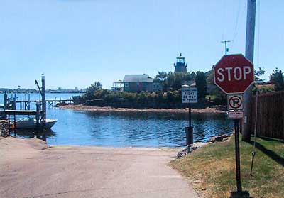
Gooseberry Road Boat Ramp
Photography by: Art Ganz and Bambi Poppick
Date of Photograph: August 17, 2006
Do you have comments, corrections or additions to the information about this site?
Help us work together to make this website better by sharing your knowledge!


Private feedback goes to the Blueways Alliance/RI Land Trust Council. We'll use your information to make this website better or pass it along to the people who can deal with physical issues at this site. Public comments are posted here (once they've been reviewed and approved) for all to see.
The data on this website come from many sources, including volunteers and organizations across the state of Rhode Island and nearby parts of Massachusetts. We have done our best to make sure the data are accurate and up to date, but any information critical to the success of your trip should be confirmed before you start. The maps and information on this website should not be substituted for nautical charts, topographic maps, or other more detailed maps and guides. We welcome corrections and additions. To send a correction or provide other feedback, please use our feedback form (see link above).
This site report was last updated on December 31, 2021
Comments:
Unusable Ramp / Ocean State/ Help
Submitted by: Anonymous; November 27, 2024; 8:25 am
Again another boat ramp that is unusable because of lack of public parking
Who is this boat ramp for? It is time for a change in the Ocean State
Some of the ramps that have public parking are often used by local businesses for business parking. HELP
Taxpayer ripoff ramp
Submitted by: Laughing Larry; February 3, 2023; 11:56 am
This ramp is a perfect example of everyone's taxes being used to provide ocean access to a few rich and connected marina owners and yacht clubs. By providing no parking this ramp exclude everyone with a boat from using this space besides the marina owners. This is another example of rich connected people using tax money for their private clubs. Ocean access is deprived in this way all the time. The rich think they own everything. Please contact your elected representatives to pressure them to stop feeding more power to the scumbags who own marinas and private clubs.
(Oh! I forgot who pays the campaign contributions that put them there.)
Rating:
No Public Parking ?
Submitted by: SJS; December 31, 2021; 8:14 am
Makes no sense at all. Just shows why Big Government is such a waste. No common sense.
Why is there no parking?
Submitted by: Anonymous; June 12, 2017; 11:36 am
Why are we maintaining a public ramp but post no parking signs all in the area? It does not make sense. Why not add parking, or at the very least add roadside parking?
Rating: