
 Zeke's Bridge Fishing Access
41° 39.91' N 71° 37.108' W See this location in: Google Maps Map Server Acme Maps
This is a site for launching boats from trailers. Boat ramps can normally be used to launch canoes and kayaks but please do your best to keep the boat ramp clear for boat trailers.
Description & Overview:
This access site is on Johnson Pond, next to the bridge that divides Johnson Pond from Reynolds Pond. Since Johnson Pond is built up and also tends to be a busy place in the summer, most paddlers who put in at Zeke's Bridge will want to head south under the bridge right next to the boat ramp, into Reynolds Pond. This bridge is low enough to keep larger boats from getting into Reynolds Pond and Reynolds Pond is also too shallow for fast boats. Reynolds is a beautiful winding pond with a mix of white pines and cedar swamps along the shore. It is largely within Big River Management Area so the shoreline is undeveloped. At the far end of Reynolds Pond you can keep going under I-95 (the tunnels under the highway are long but you can see the other end from the start) and on up Big River. For more details on Big River see the description for the access sites at Route 3. Johnson Pond is stocked and managed for Northern Pike.
If you do decide to head north from Zeke's Bridge into Johnson Pond you will find the shoreline largely lined by houses and especially once you get into Flat River Reservoir, separated from Johnson Pond by another bridge, you will find many powerboats and personal watercraft (Jet Skis) on the water, especially in the summer.
This site provides access to the following water bodies in the Pawtuxet River watershed: Big River.
Location:
Alternate Site Name: Johnsons Pond
Town: Coventry
Driving Landmarks: Take exit 6 off I-95 in West Greenwich. If you are coming from the north (Warwick), turn right at the end of the ramp; if you coming from the south (Westerly), turn left. This will put you on Route 3 (Nooseneck Hill Road) heading north. Go 1.2 miles and turn left on Harkney Hill Road. Go 1.1 miles and look for the access site on the right just before a bridge.
Access & Waters:
Water 'Features' At Site: pond, lake/reservior
Note: Because one boat launch can access, say, both a lake and a river or both the upstream and downstream portions of a river, not all paddling trips at a given site will necessarily encounter all of the features listed.
Type of Access: Boat ramp
ADA Accessible Boat Launch? no
Shoreline: Concrete boat ramp
Float/Dock: no
Hours of Operation: Closed from 1/2 hr. after sunset to 5 am, except for fishing and boating
Parking:
Parking: yes: 20 spaces
ADA Accessible Parking Spaces? no
Sources for More Information:
AMC Quiet Water Canoe Guide: 2nd Edition, page 190
Other Guidebooks: Paddle 19 in "Paddling Connecticut and Rhode Island"
Photographs:
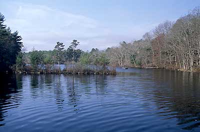
Reynolds Pond
Photography by: Bruce G. Hooke
Date of Photograph: April 20, 2008
View up Reynolds Pond from the bridge next to Zeke's Bridge Fishing Access
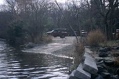
Boat ramp at Zeke's Bridge from the water
Photography by: Bruce G. Hooke
Date of Photograph: April 20, 2008
The boat ramp and parking lot at Zeke's Bridge fishing access as seen from the water. There is good access for hand-carried boats about 50 feet past the ramp, next to the parking lot. Please do not block the ramp if people with boat trailers need to use it.
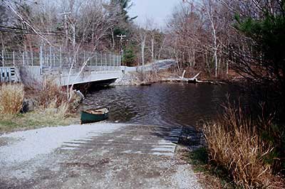
Boat ramp at Zeke's Bridge from the land
Photography by: Bruce G. Hooke
Date of Photograph: April 20, 2008
The boat ramp at Zeke's Bridge fishing access. Reynolds Pond is to the left, under the bridge. If the ramp is busy, go around to the right about 50 feet to a place where there is good access for hand-carried boats next to the parking lot. Please do not block the ramp if people with boat trailers need to use it.
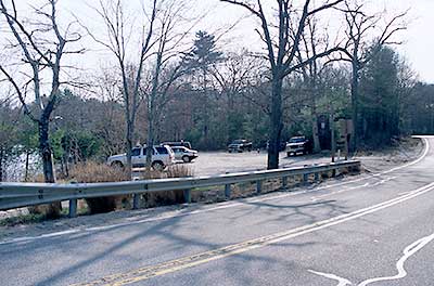
Parking lot at Zeke's Bridge Fishing Access
Photography by: Bruce G. Hooke
Date of Photograph: April 20, 2008
The parking lot at Zeke's Bridge Fishing Access
Do you have comments, corrections or additions to the information about this site?
Help us work together to make this website better by sharing your knowledge!


Private feedback goes to the Blueways Alliance/RI Land Trust Council. We'll use your information to make this website better or pass it along to the people who can deal with physical issues at this site. Public comments are posted here (once they've been reviewed and approved) for all to see.
The data on this website come from many sources, including volunteers and organizations across the state of Rhode Island and nearby parts of Massachusetts. We have done our best to make sure the data are accurate and up to date, but any information critical to the success of your trip should be confirmed before you start. The maps and information on this website should not be substituted for nautical charts, topographic maps, or other more detailed maps and guides. We welcome corrections and additions. To send a correction or provide other feedback, please use our feedback form (see link above).
This site report was last updated on January 15, 2010
Comments:
Privatized shorelines
Submitted by: Anonymous; June 30, 2017; 10:33 am
If possible, please add a public access to the Flat River Reservoir section of 'Johnson's Pond'. This is a RI treasure and should be enjoyed by all the public!