
 Cherry Street Bridge
41° 58.7' N 70° 54.727' W See this location in: Google Maps Map Server Acme Maps
This is a site for launching hand-carried boats such as canoes or kayaks.
Description & Overview:

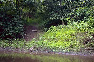
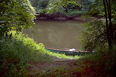
The Cherry Street Bridge provides the first reasonable access to the Taunton River below its start at the confluence of the Town and Mattfield Rivers, 2.8 miles upriver from here. The put-in/take-out is on the downriver side of the bridge, on the east side of the river (river left). From the road, go over the guardrail and look for a path leading diagonally down to the river. The path may be somewhat overgrown and you should expect some soft and slippery mud at the riverbank.
The river is broad and slow moving throughout this area and at most river levels can be paddled in either direction. Going in either direction, once you get away from the Cherry Street Bridge you will be paddling through a deep forest with almost no signs up human presence. Especially going upriver there are some trees down across the river but in most cases you can go around, over or under these trees without getting out of your boat, except when the river is low when you will have to get out and lift your boat over more of the trees.
Going downriver, after 1.4 miles of paddling through the forest on the broad, slow, tea-colored river, you will come to the broken down remnants of the Auburn Street bridge and one house is visible from the river in this area. Then the river plunges back into the deep forest for another 2.4 miles to Summer Street, the next possible take-out. The take-out at Summer Street is on the right, shortly before the bridge. For more details see the description for Summer Street.
This site provides access to the following water bodies in the Taunton River watershed: Taunton River.
Location:
Alternate Site Name: Childs Bridge
Town: Bridgewater
Nearest Town Center: Bridgewater Center and Halifax Center
Driving Landmarks: From MA 28 & 18 south of Bridgewater, head east on Flagg Street, which turns into Auburn Street. After 2.6 miles on Flagg/Auburn Street bear left onto Short Street. In another 0.3 miles bear right onto Cherry Street and continue for 1/2 mile to the river. The only available parking is some rather poor roadside parking a few hundred feet back from the bridge in either direction.
Access & Waters:
Water 'Features' At Site: flatwater/slow moving river
Note: Because one boat launch can access, say, both a lake and a river or both the upstream and downstream portions of a river, not all paddling trips at a given site will necessarily encounter all of the features listed.
Type of Access: Boat launch for hand carried boats
ADA Accessible Boat Launch? no
Shoreline: The path leading to the launch site is a bit steep and can get overgrown. The actual launch site has a low muddy bank.
Float/Dock: no
Approximate Length of Carry between Car Access and Water: 100 feet
Parking:
Parking: on street, 2 spaces, no overnight parking
ADA Accessible Parking Spaces? no
Nearby Amenities:
Public Restrooms: No
Sources for More Information:
AMC River Guide: 4th Edition, page 153
Photographs:
The Put-in/Take-out at Cherry Street, from the River
Photography by: Bruce G. Hooke
Date of Photograph: July 15, 2010
The Put-in/Take-out at Cherry Street, from the Land
Photography by: Bruce G. Hooke
Date of Photograph: July 15, 2010
Do you have comments, corrections or additions to the information about this site?
Help us work together to make this website better by sharing your knowledge!

Private feedback goes to the Blueways Alliance/RI Land Trust Council. We'll use your information to make this website better or pass it along to the people who can deal with physical issues at this site. Public comments are posted here (once they've been reviewed and approved) for all to see.
The data on this website come from many sources, including volunteers and organizations across the state of Rhode Island and nearby parts of Massachusetts. We have done our best to make sure the data are accurate and up to date, but any information critical to the success of your trip should be confirmed before you start. The maps and information on this website should not be substituted for nautical charts, topographic maps, or other more detailed maps and guides. We welcome corrections and additions. To send a correction or provide other feedback, please use our feedback form (see link above).
This site report was last updated on August 2, 2010