
 Lake Nippenicket
41° 57.87' N 71° 2.034' W See this location in: Google Maps Map Server Acme Maps
This is a site for launching boats from trailers. Boat ramps can normally be used to launch canoes and kayaks but please do your best to keep the boat ramp clear for boat trailers.
Description & Overview:
Lake Nippenicket, locally know as "The Nip," is a 354-acre natural pond. Much of the lake is bordered by Hockomock Swamp and only the higher and drier shoreline at the southern end has been developed. The lake is very shallow, averaging only 3 feet deep and with a maximum depth of just 6 feet. The wind can kick up a bit of a chop on the lake but otherwise it is a lovely place for an afternoon or evening paddle. Personal Water Craft ("Jet Skis") are permitted between 8am and 6pm.
Lake Nippenicket is also the headwaters of the Town River. To reach the start of the Town River (48 58' 52.1"N, 71 02' 34.2"W) paddle 1.25 miles north along the east shore of the lake up to the north end and look for a small stream heading into the swamp, just a bit beyond a rock-lined point and just a couple hundred feet south of the northeast corner of the lake.
The first part of the Town River is VERY narrow, winding and brushy. While water depth is not likely to be an issue, this part of the Town River is best paddled in the spring when the brush may be a little less thick. Even so, longer canoes will have a harder time than shorter boats, kayakers will find much of the channel too narrow to use their paddle normally, and sea kayaks are definitely not recommended. However, if you like penetrating deep into a swamp, this is the place for you! Like most wetlands, Hockamock Swamp is a great place to see birds and other wildlife.
When you come to a junction, stay right unless you want to explore up the Hockomock River. This junction is marked by the change from more woody growth along the river to tall cattails. Once you pass this junction the river opens out a little and the going gets easier. When finding your way thought the swamp, in general, if the current is flowing with you then you are going in the right direction, but the current is very slow moving.
1.3 miles from Lake Nippenicket the river flows under MA Route 24 and in another 0.3 miles you will come to Scotland Street, the first possible take-out. Scotland Street is 2.85 miles from the boat ramp on "The Nip." Below Scotland Street the river gets a little wider and continues to wind slowly through wetlands and forests to West Bridgewater and beyond. For more details see the descriptions for Scotland Street and War Memorial Park.
If launching hand-carried boats at the boat ramp on Lake Nippenicket please keep the boat ramp clear if there are trailered boats that need to use the ramp. The beach just west of the boat ramp provides a good alternative for hand-carried boats.
Note that most of the parking spaces for the boat ramp are reserved for vehicles with trailers, but there are some spaces for vehicles without trailers.
This site provides access to the following water bodies in the Taunton River watershed: Town River.
Location:
Alternate Site Name: The Nip
Town: Bridgewater
Nearest Town Center: Bridgewater Center
Driving Landmarks: From Route 24 north or south take Exit 15 for MA 104 (Bridgewater/Raynham). If coming from the north (from Boston) turn right at the end of the ramp and go a couple hundred feet on MA 104 west (Pleasant Street). Turn right onto Lakeside Drive and then take an almost immediate left into the parking lot for the boat ramp.
If coming from the south (from I-495) turn left at the end of the ramp and go 0.3 miles on MA 104 west. Turn right onto Lakeside Drive and then take an almost immediate left into the parking lot for the boat ramp.
Access & Waters:
Water 'Features' At Site: flatwater/slow moving river, pond
Note: Because one boat launch can access, say, both a lake and a river or both the upstream and downstream portions of a river, not all paddling trips at a given site will necessarily encounter all of the features listed.
Type of Access: Boat ramp
ADA Accessible Boat Launch? no
Shoreline: Concrete boat ramp with adjacent sandy shoreline suitable for launching hand-carried boats.
Float/Dock: no
Parking:
Parking: yes: 26 spaces
ADA Accessible Parking Spaces? yes
Nearby Amenities:
Public Restrooms: No, but restrooms should be easy to find in the commercial strip on MA 104 east of Route 24.
Sources for More Information:
AMC River Guide: 4th Edition, pages 154-155
Ecological, Cultural & Recreational Attractions:
Lake Nippenicket is a popular lake for fishing. It is especially known for its largemouth bass.
Photographs:
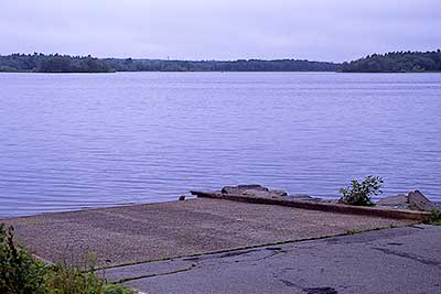
The Boat Ramp at Lake Nippenicket
Photography by: Bruce G. Hooke
Date of Photograph: July 15, 2010
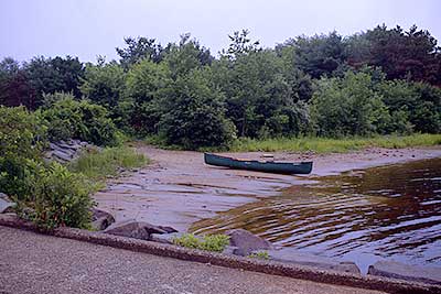
The Beach next to the Boat Ramp at Lake Nippenicket
Photography by: Bruce G. Hooke
Date of Photograph: July 15, 2010
This photograph was made in July when the lake level was probably a bit lower than it usually is in the spring.
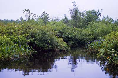
The Entrance to the Town River
Photography by: Bruce G. Hooke
Date of Photograph: July 15, 2010
This is the start of the Town River at the north end of Lake Nippenicket and there really is a route through the swamp from here, but in high summer, when this photograph was made, following that route will be a lot of work!
Do you have comments, corrections or additions to the information about this site?
Help us work together to make this website better by sharing your knowledge!


Private feedback goes to the Blueways Alliance/RI Land Trust Council. We'll use your information to make this website better or pass it along to the people who can deal with physical issues at this site. Public comments are posted here (once they've been reviewed and approved) for all to see.
The data on this website come from many sources, including volunteers and organizations across the state of Rhode Island and nearby parts of Massachusetts. We have done our best to make sure the data are accurate and up to date, but any information critical to the success of your trip should be confirmed before you start. The maps and information on this website should not be substituted for nautical charts, topographic maps, or other more detailed maps and guides. We welcome corrections and additions. To send a correction or provide other feedback, please use our feedback form (see link above).
This site report was last updated on August 2, 2010
Comments:
pretty sigma
Submitted by: jimmy; January 23, 2025; 9:01 am
yeah, I like it. pretty sigma
Rating: