
 Scotland Street
41° 59.522' N 71° 1.55' W See this location in: Google Maps Map Server Acme Maps
This is a site for launching hand-carried boats such as canoes or kayaks.
Description & Overview:

Scotland Street provides poor but usable access to the Town River below Hockomock Swamp. Getting down to the river here means going down a short but steep rip-rap slope on the downriver (east) side of the road, on the left (north) side of the river. Parking is also a problem at this site as there is only space for one or two cars. Be very careful carrying boats and gear along the side of the road and be very careful going down the rip-rap!
The benefit of this site is that it is below the part of the Town River through Hockomock Swamp that is most brushy and dense. If you want to get sense of that part of the Town River without going all the way through, you can put in at Scotland Street and paddle upriver until the going gets too thick and then turn around and go back downriver.
Paddling downriver from Scotland Street water levels should not be a problem even in late summer. The river is very slow moving and winds through wetlands and forests, but stays wide enough so that you will not be plowing through brush as on the upper part of the Town River. In 0.4 miles you will come to an old stone bridge, which will have to be portaged if the river is high. If a portage is necessary you will probably be able to portage right over the bridge, but use care as the bridge is in very poor condition. In another 0.8 miles you will come to a newer bridge with low wooden beams that will also need to be portaged (on the right) if the river is high.
2.6 miles downriver from Scotland Street is War Memorial Park in West Bridgewater, where there is a dam that must be portaged if you want to continue downriver. Take out on river left where the shoreline is grassy. For more details see the description for War Memorial Park. The river is slow moving all the way from Scotland Street to War Memorial Park so it can be paddled in either direction under most conditions.
The backwater right next to the parking area at Scotland Street looks like an easier put-in than the put-in by the bridge, but it gets closed off by brush before it gets to the main river.
This site provides access to the following water bodies in the Taunton River watershed: Town River.
Location:
Town: West Bridgewater
Nearest Town Center: West Bridgewater Center
Driving Landmarks: From Route 24 north or south take Exit 15 for MA 104 (Bridgewater/Raynham). If coming from the north (from Boston) turn left at the end of the ramp. If coming from the south (I-495) turn right at the end of the ramp. This will put you on MA 104 (Pleasant Street) heading east. Go about 1/2 mile and turn left at a traffic light onto Elm Street/Scotland Street. Go 1.7 miles north on Elm Street/Scotland Street and look for a small pull-out on the right 200 feet beyond the bridge over the river.
Access & Waters:
Water 'Features' At Site: flatwater/slow moving river
Note: Because one boat launch can access, say, both a lake and a river or both the upstream and downstream portions of a river, not all paddling trips at a given site will necessarily encounter all of the features listed.
Type of Access: Boat launch for hand carried boats
ADA Accessible Boat Launch? no
Shoreline: Steep rip rap leading to a dirt shoreline.
Float/Dock: no
Approximate Length of Carry between Car Access and Water: 200 feet
Parking:
Parking: other, 2 spaces
ADA Accessible Parking Spaces? no
Nearby Amenities:
Public Restrooms: No
Sources for More Information:
AMC River Guide: 4th Edition, pages 154-155
Ecological, Cultural & Recreational Attractions:
The parking area for this put-in/take-out is also the parking area for the "Bay Circuit Trail."
Photographs:
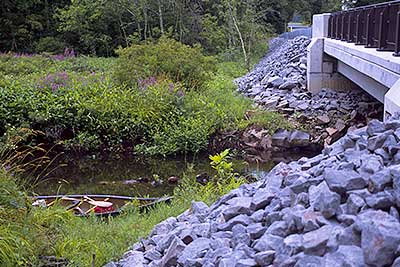
The Put-in below the Scotland Street Bridge
Photography by: Bruce G. Hooke
Date of Photograph: July 15, 2010
The access to this put-in/take-out at Scotland Street is down the rip-rap embankment in the foreground. Go carefully!
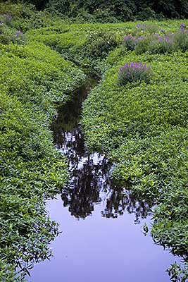
View Upriver from the Scotland Street Bridge
Photography by: Bruce G. Hooke
Date of Photograph: July 15, 2010
If you have paddled through the swamp to here, this section of the river will feel wide! Heading downriver from here the river slowly gets wider.
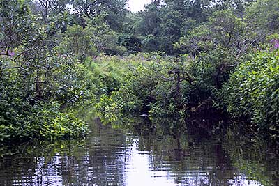
View Downriver below Scotland Street
Photography by: Bruce G. Hooke
Date of Photograph: July 15, 2010
It is hard to see in this photograph but the river bends to the left around the bush on the left and then bends right and continues through the marsh, never getting narrow enough to create serious problems for canoes and kayaks.
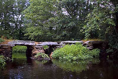
The Stone Bridge below Scotland Street
Photography by: Bruce G. Hooke
Date of Photograph: July 15, 2010
This stone bridge, 0.4 miles below Scotland Street, will have to be portaged if the river is high. This photographs is looking back upriver at the bridge, when the river was relatively low.
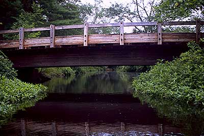
The Wood Bridge below Scotland Street
Photography by: Bruce G. Hooke
Date of Photograph: July 15, 2010
This wooden bridge is 1.2 miles below Scotland Street and will have to be portaged if the river is high enough so that you cannot fit under it.
Do you have comments, corrections or additions to the information about this site?
Help us work together to make this website better by sharing your knowledge!

Private feedback goes to the Blueways Alliance/RI Land Trust Council. We'll use your information to make this website better or pass it along to the people who can deal with physical issues at this site. Public comments are posted here (once they've been reviewed and approved) for all to see.
The data on this website come from many sources, including volunteers and organizations across the state of Rhode Island and nearby parts of Massachusetts. We have done our best to make sure the data are accurate and up to date, but any information critical to the success of your trip should be confirmed before you start. The maps and information on this website should not be substituted for nautical charts, topographic maps, or other more detailed maps and guides. We welcome corrections and additions. To send a correction or provide other feedback, please use our feedback form (see link above).
This site report was last updated on August 2, 2010