

 Wareham Street
41° 53.413' N 70° 54.222' W See this location in: Google Maps Map Server Acme Maps
This is a site for launching hand-carried boats and it is also a portage. This typically means that to continue paddling down the river past this site you will have to portage your boat around a dam or other obstruction.
Description & Overview:

If paddling downriver to this site do NOT go under the bridge. Look for a channel leading off to the right above the bridge and take out next to the head of the fish ladder and the Middleborough DPW building. Carry across Wareham Street into Thomas Memorial Park and follow the directions below.
From the parking lot for Thomas Memorial Park, to paddle downriver below the dam, carry down the path into the park and then turn right and walk along the riverbank to where there is a low point in the rocks with a bit of a gravel along the riverbank.
Below Thomas Memorial Park there is 3/4 mile of quickwater, with a Class I Whitewater rapid at about 3/8 mile where the river cuts through an old canal wall. When the river is high the quickwater does not end until the East Main Street Bridge, which must be portaged when the river is high because there is not enough space to fit under the bridge. Taking out for this portage can be tricky because the take-out is just before the bridge on the left side of the river and the river is moving quickly at this point. So, the river from Thomas Memorial Park to East Main Street is NOT recommended for inexperienced paddlers, at least when the river is high. In late summer, when the river is low, it is also much slower moving and the biggest problem is likely to be having to get out occasionally to lift your boat over rocks, but the class I whitewater drop is still there, and while it is easier at lower river levels, it still needs to be run with a bit of care.
Below East Main Street the river slows down again and remains quiet and slow-moving all the way to Oliver Mill Park at Route 44.
Click here for a printable map and guide (in Adobe Acrobat format) to paddling this part of the Nemasket River.
This site provides access to the following water bodies in the Taunton River watershed: Nemasket River.
Location:
Alternate Site Name: Thomas Memorial Park
Town: Middleborough
Nearest Town Center: Middleborough
Driving Landmarks: From I-495 north or south take the Exit 4 for Route 105, Middleboro Center and Lakeville. If you are coming from the north go left at the end of the ramp. If you are coming from the south go right at the end of the ramp. This will put you on South Main Street (Route 105) heading northeast. Go about a mile and turn right onto Wareham/Centre Street. Go 0.3 miles and look for a parking area along the left side of the road at Thomas Memorial Park, across the street from the Middleborough DPW building.
Access & Waters:
Water 'Features' At Site: dam, whitewater, flatwater/slow moving river
Note: Because one boat launch can access, say, both a lake and a river or both the upstream and downstream portions of a river, not all paddling trips at a given site will necessarily encounter all of the features listed.
Type of Access: Boat launch for hand carried boats
ADA Accessible Boat Launch? no
Shoreline: Rocks and earth above the dam, rocks and gravel below the dam
Float/Dock: no
Approximate Length of Carry between Car Access and Water: 150 feet
Portage Length: 400 feet
Parking:
Parking: yes: 10 spaces
ADA Accessible Parking Spaces? yes
Nearby Amenities:
Public Restrooms: No
Sources for More Information:
AMC River Guide: 4th Edition, page 157
Website: Map and Guide to paddling the upper Nemsket River (Adobe Acrobat format)
Photographs:
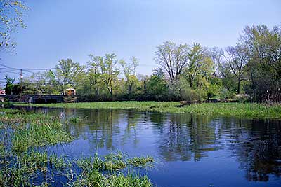
View of the Take-Out at Wareham Street
Photography by: Bruce G. Hooke
Date of Photograph: May 1, 2010
Do NOT go under the bridge at left. Instead, use the small channel leading off to the right in this photo to land and take-out near the head of the fish ladder.
Note that this photo was taken in the spring when the river was quite high. In late summer when the river is lower the greenery on the right is too high to see over from a canoe or kayak, but the channel leading to the take-out is still there.
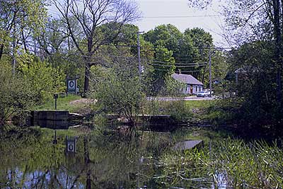
Close View of the Take-Out at Wareham Street
Photography by: Bruce G. Hooke
Date of Photograph: May 1, 2010
A closer view of the landing above the bridge and dam at Wareham Street. The head of the fish ladder is on the left. The better take-out is on the right side of the picture in line with the house in the background.
Note that this photo was taken in the spring when the river was quite high. In late summer the greenery closes in quite a bit, but there is still a narrow channel leading from the river to the take-out.
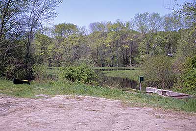
The Take-Out at Wareham Street from the Land
Photography by: Bruce G. Hooke
Date of Photograph: May 1, 2010
Looking back at the take-out at Wareham Street from the land. The head of the fish ladder is on the right. The canoe on the left is at the better take-out.
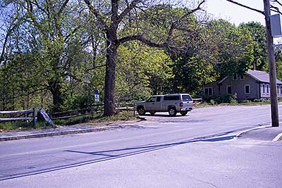
The Parking Area at Wareham Street
Photography by: Bruce G. Hooke
Date of Photograph: May 1, 2010
The parking along Wareham Street for Thomas Memorial Park is on the right in this photograph and the entrance to the park is to the left of the large tree. The put-in below the bridge and dam is down this path. The take-out is behind the photographer.
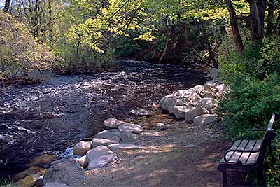
The Put-in Below Wareham Street
Photography by: Bruce G. Hooke
Date of Photograph: May 1, 2010
The put-in below the dam and bridge at Wareham Street goes directly into quickly moving water, as this photograph shows, and the water does not really slow down that much until East Main Street when the river is high. This photograph was made in the spring when the river was high. When the river is lower the water is much slower moving here and in a dry summer you will likely have to get out of your canoe or kayak occasionally to lift it over rocks.
Do you have comments, corrections or additions to the information about this site?
Help us work together to make this website better by sharing your knowledge!

Private feedback goes to the Blueways Alliance/RI Land Trust Council. We'll use your information to make this website better or pass it along to the people who can deal with physical issues at this site. Public comments are posted here (once they've been reviewed and approved) for all to see.
The data on this website come from many sources, including volunteers and organizations across the state of Rhode Island and nearby parts of Massachusetts. We have done our best to make sure the data are accurate and up to date, but any information critical to the success of your trip should be confirmed before you start. The maps and information on this website should not be substituted for nautical charts, topographic maps, or other more detailed maps and guides. We welcome corrections and additions. To send a correction or provide other feedback, please use our feedback form (see link above).
This site report was last updated on August 29, 2010