

 Sprague Farm
Glocester, Glocester Land Trust

![]() 6.0 miles of trail
6.0 miles of trail
Moderate
Hunting is permitted here in season. Wear blaze orange during hunting season. More information
Click on the "Trail Map (PDF)" button to download a PDF of the trail map that you can print and take with you on the trail.
Avenza maps are special, free maps that you can use in the Avenza app on your smart phone. These maps let you see your location on the map as you walk. Download the Avenza App for free in the Apple App Store or on Google Play
Click on the Avenza Trail Map button to "purchase" the free map for this trail from the Avenza map store. If this is your first time, Avenza will ask you to set up an account to check out. However, all Avenza trail maps listed on ExploreRI are free.
In Rhode Island the primary hunting seasons typically run from the second Saturday in September to the last day of February and from the third Saturday in April to the last day in May, however this can vary from year to year and depends on what game is being hunted. During hunting season you should wear at least 200 square inches (a hat OR a vest) of blaze orange. During shotgun deer season, which is typically in December, you should wear at least 500 square inches of blaze orange (a hat AND a vest). For more information see the RI DEM website.

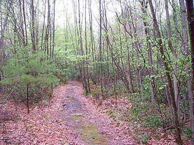

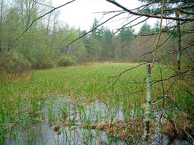


Sprague Farm is approximately 1,200 acres of forest. Within Sprague Farm there are several miles of wide dirt/gravel roads used by area farmers for generations, and several miles of narrower foot paths created by the Glocester Land Trust. Most trails have a gentle slope and visit scenic ledge vistas, stands of Striped Maple, a glacial fen, an Atlantic White Cedar wetland, several fields, miles of stone walls, stone slab bridges over several streams, the Sprague family cemetery, and stone foundation walls for barns and farmhouses.
The Glocester Land Trust began acquiring Sprague Farm in 1990 with the purchase of 247 acres which was the core and last remaining actively farmed area. In the intervening years the Land Trust has quadrupled the area protected from development by acquiring adjacent parcels which are called woodlands. Acquisition funding was from a combination of Town of Glocester Open Space Bonds, RI DEM Open Space Bonds, The Nature Conservancy, Champlain Foundations, and private contributions.
In 2009 Sprague Farm was the site of RI Natural History Survey's BioBlitz. In a 24 hour period, professional and amateur scientists explored Sprague Farm and found nearly 1,000 different wildlife species. Sprague Farm is featured in Ken Weber's book 'Weekend Walks in Rhode Island.'
Sprague Farm is open year round from sunrise to sunset. During the fall this area is open for deer and turkey hunting. During the winter months Sprague Farm is open for snowshoeing and cross country skiing. In warm weather Sprague Farm is a popular place for horseback riding, jogging, geocaching, dog walks, and casual walks.
Dogs: Yes: must be under owners control (voice or leash). Remove/knock waste off trail.
Horses: Yes: To minimize erosion, no riding for 48 hours after heavy rain. Primary trailer parking is at the Pine Orchard Rd - Loop Trail trailhead. Other parking areas are large enough for a few trailers.
Bicycles: Yes: only on wide gravel trails. To minimize erosion, no riding for 48 hours after heavy rain.
Other Amenities: None
This is a Creature Challenge site. The creature is on the Sprague Trail.
Learn more about the Creature Challenge.

Loop Trail Trailhead
Driving Landmarks: The parking area for this trailhead is across the road from 162 Pine Orchard Road, Glocester, which is about 0.8 miles south of where Pine Orchard Road takes off from Route 44.
Parking: Yes: Parking lot, 15 spaces, no overnight parking
ADA Accessible Parking Spaces? No
Coordinates: 41° 54.53' N 71° 42.15' W See this location in: Google Maps Acme Maps
Kilmartin Woodland Trailhead
Driving Landmarks: There is a dirt parking lot for this trailhead at the southern end of Sprague Hill Road (gravel), at the junction with Elbow Rock Road, one mile south of Route 44 (Putnam Pike).
Parking: Yes: Parking lot, 8 spaces, no overnight parking
ADA Accessible Parking Spaces? No
Coordinates: 41° 54.37' N 71° 43.76' W See this location in: Google Maps Acme Maps
Huckins Woodland Trailhead
Driving Landmarks: The parking lot for this trailhead is next to (just east of) 1736 Putnam Pike (Route 44), Glocester.
Parking: Yes: Parking lot, 8 spaces, no overnight parking
ADA Accessible Parking Spaces? No
Coordinates: 41° 55.2' N 71° 43.13' W See this location in: Google Maps Acme Maps
KEY:
Trailhead
Only trailheads related to this trail system are shown on this map. To see all trailheads go to the main map.
Do you have comments, corrections or additions to the information about this site?
Help us work together to make this website better by sharing your knowledge!


Private feedback goes to the Blueways Alliance/RI Land Trust Council. We'll use your information to make this website better or pass it along to the people who can deal with physical issues at this site. Public comments are posted here (once they've been reviewed and approved) for all to see.
The data on this website come from many sources, including volunteers and organizations across the state of Rhode Island and nearby parts of Massachusetts. We have done our best to make sure the data are accurate and up to date, but any information critical to the success of your trip should be confirmed before you start. The maps and information on this website should not be substituted for topographic maps or other more detailed maps and guides. We welcome corrections and additions. To send a correction or provide other feedback, please use our feedback form (see link above).
This site report was last updated on January 12, 2025
Comments:
Sprague Farm map update
Submitted by: Tom Belleville; January 12, 2025; 11:51 am
Trail map on the web site needs to be updated to show the green blazed trail highlighted in the 1/12/2025 PROJO.
[Moderator's Comment: Thank you for the heads up. We just posted an updated map.]
Great walk
Submitted by: Anonymous; October 3, 2024; 9:41 pm
Wonderful walk today. The Sprague farm was extremely interesting. Not only was it a good hike but it was a history lesson as well. We enjoyed the trip immensely And plan to go back. We didn't get a chance to see the Sprague cemetery and we want to.
Rating:
Map Quality
Submitted by: John; April 26, 2023; 9:57 am
We found the map posted on the trailhead information board (see attached photo) much more useful than the map here or on the Glocester Land Trust page since there are new trails available. My updated Geocaching App map doesn't even show the new trails yet so I'm glad we took a photo of the map at the trailhead on Pine Orchard Road.
Rating:
Photographs:
Photo Credit: John
Useless Maps
Submitted by: Tom R; March 24, 2020; 3:28 pm
Come On DEM. These maps don't show trails or trail names. That makes them nearly useless. You can do better than this!
Rating: