

Water Trail Maps:
Want a route mapped out for you to paddle? This is the page for you! Below are links to over 30 water trail maps for paddling trips throughout Rhode Island and the Narragansett Bay Watershed: from the Blackstone River in the north to the salt ponds in the south, and from the Taunton River watershed in the east to the Wood-Pawcatuck in the west. All maps can be downloaded and printed for free. All maps are in Adobe Acrobat format and require the free Adobe Acrobat Reader to open.
For information on the many printed books and maps available for Rhode Island and the Narragansett Bay Watershed see the Maps and Books page. For information put-ins so you can "make your own trip," see the boat launch map.
Click on the names below for more details on the paddle maps for that area
What is a "Water Trail"? You won't find trail markers or trail signs on a water trail. What you will find is a route that has been scouted by experienced paddlers and described and shown on the maps below, with information about the experience level recommended for the route, where to put in and take out, what to expect on the water, and lots of other useful information for specifically for paddlers. Many of the maps also talk about the history of the area or the wildlife you may see on the paddle.
 Blackstone River
The National Park Service has created a great series of maps for paddling on the Blackstone River. Theses maps break the river up into segments with suggested tours within each river segment. Note that many of the maps and tours overlap. The maps include suggested put-ins and take-outs as well as route information and lots of interesting and useful background information including such thing as historic sites to see along the route. For general information about paddling on the Blackstone River, see this National Park Service web page. The PDFs below can also be downloaded there.
Note that some of the tours are marked intermediate and some are marked beginner. The intermediate tours require more skill on the part of the paddlers.
The tours are listed below from north to south, from the upper reaches of the Blackstone in Massachusetts to near the mouth in Rhode Island.
NOTE: These maps were created a number of years ago now and have not been updated so conditions may have changed in some areas.
WARNING: Before attempting to paddle downriver from Plummer's Landing read the important updates about the river's changing course on the page about Plummer's Landing. Presumably because of these changes in the river, this map is no longer available.
Massachusetts Tours:
- River Bend Farm - Beginner and Intermediate Tours (possible round-trips)
- River Bend Farm to Blackstone Gorge - Intermediate Tour
- Blackstone Gorge to Millville Lock (round trip)- Beginner Tour
Rhode Island Tours:
Bristol Area
Bristol, Rhode Island is one of New England’s famous historic ports. The well-preserved waterfront district and surrounding areas contain wonderful old buildings, churches, mills, mansions and ship building facilities that tell the history of Bristol’s development since its founding in 1680. Today, restaurants, shops and public parks provide visitors with many options to make Bristol the ideal spot to launch your next paddling experience. The maps below were developed by the Bristol Conservation Commission in partnership with the RI Blueways Alliance. They offer various kayaking routes that will allow you to experience Bristol from the proper perspective, on the water!
Buckeye Brook
Buckeye Brook originates in Spring Green Pond near Hoxsie Four Corners in Warwick, flowing under Airport Road and into Warwick Pond before continuing southeast to Narragansett Bay. Its watershed includes much of central Warwick. South of Buckeye Brook’s mouth, Warwick’s shoreline is comprised of Victorian era neighborhoods leading to Rocky Point Park.
The Lower Brook paddle is a 3.75 mile (round trip), 2-hour paddle from Conimicut Point in Warwick through Mill Cove and up Buckeye Brook, and then back down to Conimicut Point.
The Brook to Bay paddle is a 3.5 mile (round trip), 3-hour paddle south from Conimicut Point down the bay, along the Warwick shore, around Rocky Point, and back.
These maps were created through a partnership between the Rhode Island Blueways Alliance, the Narragansett Bay Estuary Program, and the Buckeye Brook Coalition; and funded by a grant from the Rhode Island Foundation.
Kickemuit River
The portion of the Kickemuit River covered by these maps is actually a broad tidal estuary in Warren and Bristol. At its widest, this part of the Kickemuit is over half a mile wide. It is a little over 2 miles from the head, below the dam that forms Warren Reservoir, to the mouth at Bristol Narrows, where the Kickemuit flows into Mount Hope Bay (and Mount Hope Bay flows into the Kickemuit when the tide is rising!). The shoreline of the river is a mix of farmland, residential neighborhoods, and conservation land, including the Audubon Society of Rhode Island’s Touisset Marsh Wildlife Refuge.
The Warren Loop paddle is the easier paddle because it stays inside Bristol Narrows. This paddle is a 4.75 mile loop starting at the north end of the estuary or along the western shore at the Harris Avenue access point. The loop takes you down one side of the river and up the other side.
The Warren-Bristol Loop starts outside the narrows at the Mount Hope Fishing Access site and takes you north through the narrows, and then largely follows the route of the Warren Loop, before going back out through the narrows to the starting point. This is a 6.5 mile loop.
These maps were created through a partnership between the Rhode Island Blueways Alliance, the Narragansett Bay Estuary Program, and the Kickemuit River Council; and funded by a grant from the Rhode Island Foundation.
Narrow River
The Pettaquamscutt River, universally known locally as the Narrow River, is contrary to its name a tidal estuary often over 300 feet wide and in places over ¼ mile wide. The tide and wind often interact to create dangerous conditions at the mouth, where the river flows into Narragansett Bay at the north end of Narragansett Beach. However, both of these paddles stay above the Route 1A bridge, where the waters are sheltered and the biggest hazard presented by the tide is usually grounding out on shoals in the lower river. The shoreline is a mix of residential neighborhoods and salt marshes, many of which are part of the John H. Chafee National Wildlife Refuge. The salt marshes and sheltered tidal waters make this a great place for wildlife, especially birds.
The Upper Pettaquamscutt River paddle is a 4.5 mile loop on the ponds at the upper end of the river, where the tide has less influence and motor boats are also less common than on the lower river. Much of the shoreline in this area is wooded.
The Lower Pettaquamscutt River & Cove paddle is a 5 mile loop amongst the scenic salt marshes and tidal flats of the lower river. Pay attention to the directions on the map regarding staying out of the way of motorboats while avoiding going aground.
These maps were created through a partnership between the Rhode Island Blueways Alliance, the Narragansett Bay Estuary Program, and the Narrow River Preservation Association, and funded by a grant from the Rhode Island Foundation.
Olney and Barney Ponds, Moshassuck Watershed
The Moshassuck Watershed extends northwest from the middle of Providence up into Lincoln. The river is generally too shallow to paddle but there are lakes in the watershed that are excellent for paddling. Both of the paddles listed here are just 15 minutes from downtown Providence but are in pretty wooded landscapes. Olney Pond is the centerpiece of Lincoln Woods State Park, and its 126 acres offer many coves and islands to explore by canoe or kayak. However, it can be a busy place on a summer weekend. Barney Pond is on the eastern edge of Lincoln Woods State Park, between the park and a suburban neighborhood. At 24 acres it is quite a bit smaller than Olney Pond but it is likely to be quite a bit quieter on weekends when Olney Pond is busy.
These maps were created through a partnership between the Rhode Island Blueways Alliance, the Narragansett Bay Estuary Program, and the Friends of the Moshassuck; and funded by a grant from the Rhode Island Foundation.
Pawcatuck River
The Pawcatuck River, a designated US Wild and Scenic River, traverses a large part of southwest Rhode Island. Along the way it flows through wild swamps, and rural lands, as well as through the middle of the town of Westerly, where it flows into the sea. The river is narrow and winding at its headwaters and widens into a mostly quiet river. There are occasional sections of whitewater and various dams so read the descriptions carefully and pick a paddle that is suitable for your level of experience. Note that while the Wood River is part of the overall Wood-Pawcatuck Watershed, the Wood River paddle trails are listed separately under the Wood River.
For more information on paddling in the Wood-Pawcatuck watershed see the Wood-Pawcatuck Watershed Association’s paddling guide.
The Taylor's Landing to Biscuit City Landing paddle starts at Route 138 and quickly enters the vast Great Swamp. The Chipuxet River twists and turns through the swamp until it reaches Worden Pond. At Worden Pond you can either follow the eastern shore to the boat ramp on the south side of the pond or follow the north shore to the inconspicuous entrance to the Pawcatuck River. Here you once again enter a wetland but this time the wetland is forested. Downed trees are common, as is, unfortunately, poison ivy. If you persist you will reach the junction with the Usquepaugh. From here the river is wider and the paddling normally easier, down to the small side channel that leads to the take-out at Biscuit City Landing.
The Biscuit City to Cronan paddle starts at Biscuit City Landing and follows the Pawcatuck River for 6 miles down to the John (Jay) Cronan Fishing Access site. Along the way you will encounter a number of dams as well as various short sections of whitewater. The dams must be portaged and most of the whitewater can be portaged but one section of whitewater cannot be portaged and must be run. However, aside from the dams and short sections of whitewater this is generally a quiet paddle through rural and forested lands.
The Cronan to Potter Hill paddle follows the Pawcatuck River for 16 miles from the John (Jay) Cronan Fishing Access site down to Potter Hill. There is the option of taking out at about the halfway point, at Bradford. At Burdickville there are the remnants of an old dam that can sometimes be run if the water is high but which must otherwise be portaged. Immediately below Bradford there are a number of dams that most paddlers will choose to portage. Otherwise, this paddle is on quiet waters that pass through rural and forested landscapes.
The Potter Hill to Westerly paddle follows the Pawcatuck River for 7 miles from the access point at the end of Post Office Lane down to Westerly, Rhode Island. There is some whitewater at the site of the former dam at White Rock and at the remnant dam at Stillman Avenue. The latter can be portaged. Otherwise, this section of the river is quiet, with forested banks and only a few bridges, at least until you get to Westerly, where the river becomes more urban. Below Westerly the river widens into a tidal estuary as it flows into the sea.
- The Chipuxet and Pawcatuck Rivers: Taylor's Landing to Biscuit City Landing via Worden Pond
- Biscuit City Landing to Cronin Fishing Access
- Cronan Fishing Access to Potter Hill Mill
- Potter Hill Mill to Westerly
These maps were developed by the Wood-Pawcatuck Watershed Association and are shared here thanks to the generosity of that organization.
Pawtuxet River
The Pawtuxet River in Warwick and Cranston flows through dense urban and suburban neighborhoods but feels surprisingly wild because the floodplains along the river have kept much of the development back from the river and left the river to flow through a wooded corridor. The Pawtuxet has also benefited from a great deal of work that has been done in recent decades to clean up the river. However, the biggest change in the river in recent years was the removal of the dam at the mouth, restoring the tidal falls that used to be there. At high tide the falls are submerged and with careful attention to the tides it is possible to paddle between the river and the salt water of Pawtuxet Cove. At low tide the river’s water falls over a bedrock ledge in a cascade of whitewater.
The Lower Pawtuxet River paddle is a 6.5 mile one-way paddle from the Pontiac Canoe Launch in Warwick to Rhodes on the Pawtuxet in Cranston, ½ mile above the mouth of the river. There are some places with faster moving water on this paddle so some experience is recommended.
The Rhodes to Pawtuxet Cove paddle is a 2 mile round trip paddle out the mouth of the river and back, through the area where the dam was removed and the falls restored. See the map for details on planning your trip around the tides. You can also stay above the mouth and simply explore the quiet waters of the Pawtuxet between Rhodes and the mouth.
These maps were created through a partnership between the Rhode Island Blueways Alliance, the Narragansett Bay Estuary Program, and the Pawtuxet River Authority and Watershed Council; and funded by a grant from the Rhode Island Foundation.
Roger Williams Trail
In 1636, when Roger Williams arrived in Rhode Island with his followers to settle and start what would become the State of Rhode Island he arrived by boat, paddling from what is now East Providence down the Seekonk River, around Fox and India Points to Providence. The map and guide provide information on retracing parts of Williams' route and also provides some interesting history about how Roger Williams came to Providence.
This map was created through a partnership between the Rhode Island Blueways Alliance and the Ten Mile River Watershed Council, and funded by a grant from outdoor retailer REI. The National Park Service provided assistance with the historical information on the map.
South County Salt Ponds
The salt ponds along the south coast of Rhode Island between Point Judith in Narragansett and Watch Hill in Westerly are ecologically important and scenically beautiful. Most are coastal lagoons behind the long straight beach that forms the outer coast, with no major rivers flowing into them, but Point Judith Pond is considered an estuary at the mouth of the Saugatucket River. The mouths of these ponds, where they connect to the open ocean, are dangerous places even in large boats, because the surf and tidal currents can create strong currents and large breaking waves. The exception is Point Judith Pond, where the mouth is well protected by extensive breakwaters, but this area should be avoided by paddlers due to the many large commercial boats that travel this narrow waterway. Fortunately all of these paddles avoid the mouths of the ponds and lead you around islands, through salt marshes, and past wooded shorelines and sand dunes. The paddles are listed below from east to west.
The Point Judith Pond paddle takes you on a 5.5 mile loop of the quieter upper reaches of the pond, including the narrows between the Upper Pond and the main part of the pond. The main channel is heavily used by motorboats and sailboats that moor in the Upper Pond, but away from this channel the waters are quieter, especially once you go through the narrows into the main part of the pond. The shoreline is a mix of woods, residential neighborhoods and marinas.
The Green Hill Pond paddle is a 6 mile loop past islands and salt marshes. Green Hill Pond is an eastern extension of Ninigret Pond and is relatively lightly traveled by motorboats and other larger craft. There are many coves and islands to explore. The shoreline is a mix of woods, residential neighborhoods and extensive salt marshes.
The Ninigret Pond paddle is a 4.5 mile loop amongst salt marshes and wooded shores, with many options for longer trips. Major sections of the shoreline are conserved through various types of parks and refuges, including Ninigret National Wildlife Refuge.
The Quonochontaug Pond paddle is a 4.5 mile loop through what is often called “Quonnie Pond.” Much of the shoreline is natural and undeveloped. The paddle includes a place where you can land and follow a path through the dunes to the ocean beach.
These maps were created through a partnership between the Rhode Island Blueways Alliance, the Narragansett Bay Estuary Program, and the Salt Ponds Coalition; and funded by a grant from the Rhode Island Foundation.
Taunton River Watershed
The Taunton watershed covers 562 square miles in southeast Massachusetts, stretching east to the edge of Plymouth and north to the suburbs of Boston. It flows into Mount Hope Bay, on the east side of Narragansett Bay, at Fall River. In 2009 the Taunton River was designated a National Wild and Scenic River so it should be no surprise that there are lots of great places to go paddling in the Taunton watershed. The maps below cover just two of the many paddles.
The Upper Nemasket River paddle starts near the head of the Nemasket River in Lakeville and goes down river, 5.3 miles to Oliver Mill Park in Middleborough. The scenery varies from forests and wetlands to a few stretches of suburban neighborhoods. There is some faster moving water so this paddle is recommended for more experienced paddlers. The upper part of the river is all flatwater so if you want just flatwater paddling you can take out at Wareham Street in Middleborough, 3.2 miles from the put-in.
The Weir Village Riverfront Park to Dighton Rock paddle is at the other end of the watershed, below Taunton where the river is starting to slowly widen out into a tidal estuary. Weir Village Riverfront Park is in Taunton and the first part of this paddle is through a fairly urban landscape, but the city quickly gives way to quiet wooded shores that slowly develop salt marshes as you head downriver. The take-out is at Dighton Rock State Park in Berkley, where the river is over ¼ mile wide.
These maps were created through a partnership between the Rhode Island Blueways Alliance and the Taunton River Watershed Alliance, with funding from the Taunton River Coalition.
Ten Mile River
The Ten Mile River flows into the Seekonk River in East Providence and extends north 13 miles to Plainville, Massachusetts. It flows through a wide variety of landscapes, from suburban neighborhoods to dense forests, and includes narrow winding stretches as well as the broad open waters of Turner Reservoir and Central Pond.
The Central Pond and Turner Reservoir paddle provides various options for exploring this long, connected water body along the Rhode Island–Massachusetts line, between East Providence and Seekonk. Turner Reservoir was once used to supply drinking water to East Providence but does not any more.
The Freedom Green to Hunts Mills paddle is a 3-mile up and back paddle on the lowest part of the Ten Mile River, where it is flowing north and east from Turner Reservoir into Omega Pond, from where it flows over a dam into the Seekonk River. This paddle takes you through a suburban neighborhood and into a wooded area that feels far from the city. NOTE: As of the middle of June 2026 there is reportedly a large tree down across the river about 1/4 mile downriver from Freedom Green that completely blocks the river making it entirely impassable. If anyone has updated information about this, please let us know so we can spread the word.
These maps were created through a partnership between the Rhode Island Blueways Alliance, the Narragansett Bay Estuary Program, and the Ten Mile River Watershed Council; and funded by a grant from the Rhode Island Foundation.
Warwick Area Saltwater Paddles
Greenwich Bay and the coves and rivers that flow into it, as well as the shoreline north and south from Greenwich Bay, offer some fine options for sea kayaking, readily accessible to the major population centers in Rhode Island. This series of maps, created by the Warwick Wildlife and Conservation Commission, provides information about various paddling routes in this area. See the Buckeye Brook list above for two more saltwater paddle in this area.
- Pawtuxet Cove to Conimicut Point
- Warwick Cove to Apponaug Cove
- Greenwich Cove to Apponaug Cove
- Greenwich Cove to Sandy Point
- Sandy Point up Greene's River and Return
These maps were created by the Warwick Wildlife and Conservation Commission.
Wood River
The Wood River, a designated US Wild and Scenic River, flows through some of the most pristine woods in Rhode Island, and indeed some of the most pristine woods between Boston and New York. The river starts in Coventry, Rhode Island and Sterling, Connecticut and ends where it flows into the Pawcatuck River, where Hopkinton, Charlestown, and Richmond come together. There is also excellent paddling on the Pawcatuck River but these two paddles focus on the Wood River. For more information on paddling in the Wood-Pawcatuck watershed see the Wood-Pawcatuck Watershed Association’s paddling guide.
The Upper Wood River paddle starts at Ten Rod Road in Exeter and goes 7.5 miles south to Wyoming Pond in Hopkinton, with a portage at the Barberville Dam. For much of the paddle the river winds through the deep forest of Arcadia Management Area. Besides the class I whitewater sections, good maneuvering skills are required to navigate around the many twists, turns and obstacles in the river, so this paddle is recommended for “intermediate plus” and experienced paddlers. See the map for an alternate option that is all on flatwater.
The Lower Wood River paddle starts in Hope Valley, below Wyoming Pond, and goes 9 mile south to Alton Pond, just above where the Wood River flows into the Pawcatuck River. There are at least two portages around dams on this paddle, but for much of the route the river winds past wooded banks, often covered in mountain laurel, swamp azalea, silky dogwood, and swamp rose. The fast moving water and many obstacles in this section require good boat control, so this paddle is recommended for intermediate and experienced paddlers.
These maps were created through a partnership between the Rhode Island Blueways Alliance, the Narragansett Bay Estuary Program, and the Wood-Pawcatuck Watershed Association, and funded by a grant from the Rhode Island Foundation.
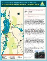
Woonasquatucket River
The Woonasquatucket River starts in North Smithfield, Rhode Island, and flows 17 miles south to downtown Providence where it joins with the Moshassuck River to from the Providence River, just downhill from the Rhode Island State Capitol. In the distance it passes through woods and suburbs before flowing into the city, and offers a range of paddling opportunities. These two paddles are at opposite ends of the watershed and offer very different scenery. A downloadable booklet with seven paddling routes in the Woonasquatucket River watershed, including the two listed below, is available on the paddling page of the Woonasquatucket River Watershed Council website.
The Woonasquatucket Reservoir & Stillwater Pond map shows a number of options for paddling on Woonasquatucket Reservoir and Stillwater Pond in Smithfield. A loop of up to 5 miles can be made on Woonasquatucket Reservoir. The shore of Woonasquatucket Reservoir is a mix of forest and some suburban neighborhoods. The paddle to and on Stillwater Pond is through deeper woods, further from roads and houses. Since the Woonasquatucket Reservoir paddle is all on flatwater it is suitable for beginners as long as there is not too much wind. The alternate paddle on Stillwater Pond includes some moving water and a narrow, winding channel, as well as a somewhat difficult put-in, so it is best for intermediate and experienced paddlers.
The Woonasquatucket River in Providence takes you through the middle of Providence, past the State House, under the mall, and on into a wooded corridor in the Valley neighborhood of Providence. It is a 4-mile round-trip paddle from the South Water Street landing up to near where Atwells Avenue crosses the river, and back. The route is all easy flatwater paddling as long as you time your trip to the tides. Experienced paddlers can also start at Donigian Park and paddle one way down to South Water Street but this paddle involves some fast moving water in a narrow, winding, rocky channel so it is only recommended for experienced paddlers.
These maps were created through a partnership between the Rhode Island Blueways Alliance, the Narragansett Bay Estuary Program, and the Woonasquatucket River Watershed Council; and funded by a grant from the Rhode Island Foundation.