

 Mercy Woods
Cumberland, Cumberland Land Trust


![]() 6.0 miles of trail
6.0 miles of trail
Moderate
Click on the "Trail Map (PDF)" button to download a PDF of the trail map that you can print and take with you on the trail.
Avenza maps are special, free maps that you can use in the Avenza app on your smart phone. These maps let you see your location on the map as you walk. Download the Avenza App for free in the Apple App Store or on Google Play
Click on the Avenza Trail Map button to "purchase" the free map for this trail from the Avenza map store. If this is your first time, Avenza will ask you to set up an account to check out. However, all Avenza trail maps listed on ExploreRI are free.
In Rhode Island the primary hunting seasons typically run from the second Saturday in September to the last day of February and from the third Saturday in April to the last day in May, however this can vary from year to year and depends on what game is being hunted. During hunting season you should wear at least 200 square inches (a hat OR a vest) of blaze orange. During shotgun deer season, which is typically in December, you should wear at least 500 square inches of blaze orange (a hat AND a vest). For more information see the RI DEM website.


In 2018 the religious order of Sisters of Mercy sold 229 acres of open space to the Town of Cumberland. 18 acres are to be developed into athletic fields and the remaining 211 acres will remain as undeveloped open space managed by the Cumberland Land Trust.
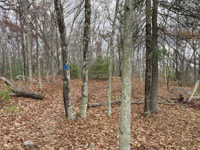
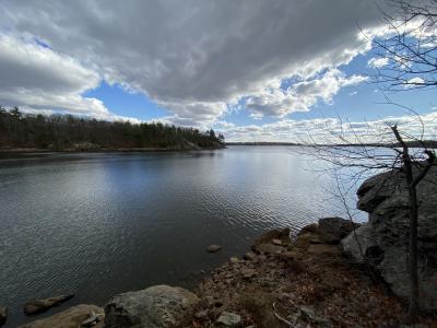
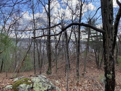
The yellow blazed Mercy Loop is relatively easy to walk with gently rolling trails about four feet wide. A vista overlooking the forest and reservoir is at the southeast tip of the trail loop. The section of trail between Sumner Brown Rd and Highland View Road was an apple orchard until the 1950's.
The blue blazed Ridge Trail is a more challenging walk with several steep ridges. The Ridge Trail has vistas at the southeast and northeast sections. Some of the Ridge Trail and most of the red blazed connecting trails are wide farmers cart paths. The athletic field area was formerly a dairy farm and the farmers cart paths connected cattle pastures and wood lots to the barns and farmhouse.
Dogs: Yes, must be leashed and waste removed by owner
This is a Creature Challenge site. The creature is on the Grape Trail.
Learn more about the Creature Challenge.

Highland View Road Trailhead
Driving Landmarks: This trailhead is on Highland View Road beside a field just before the Sisters of Mercy Administration Building.
Parking: Yes: Parking lot, 10 spaces, no overnight parking
ADA Accessible Parking Spaces? No
Coordinates: 42° 0.581' N 71° 24.538' W See this location in: Google Maps Acme Maps
Sumner Brown Road Trailhead
Driving Landmarks: This trailhead is on Sumner Brown Road, 200 yards from the junction with Wrentham Road (Route 121)
Parking: Yes: Parking lot, 10 spaces, no overnight parking
ADA Accessible Parking Spaces? No
Coordinates: 42° 0.881' N 71° 24.806' W See this location in: Google Maps Acme Maps
Wrentham Road Spur Trailhead
Driving Landmarks: A spur on the east side of Wrentham Road between Sumner Brown Road and the State Line provides access to this trailhead. As of April 2019 the town is awaiting official permission from RI DOT to use this abandoned road for parking. Until such permission is forthcoming it may be wiser to park at one of the other trailheads.
Parking: Yes: On street, 15 spaces, no overnight parking
ADA Accessible Parking Spaces? No
Coordinates: 42° 1.012' N 71° 24.919' W See this location in: Google Maps Acme Maps
KEY:
Trailhead
Only trailheads related to this trail system are shown on this map. To see all trailheads go to the main map.
Do you have comments, corrections or additions to the information about this site?
Help us work together to make this website better by sharing your knowledge!


Private feedback goes to the Blueways Alliance/RI Land Trust Council. We'll use your information to make this website better or pass it along to the people who can deal with physical issues at this site. Public comments are posted here (once they've been reviewed and approved) for all to see.
The data on this website come from many sources, including volunteers and organizations across the state of Rhode Island and nearby parts of Massachusetts. We have done our best to make sure the data are accurate and up to date, but any information critical to the success of your trip should be confirmed before you start. The maps and information on this website should not be substituted for topographic maps or other more detailed maps and guides. We welcome corrections and additions. To send a correction or provide other feedback, please use our feedback form (see link above).
This site report was last updated on September 21, 2023
Comments:
Very nice trail
Submitted by: Anonymous; November 14, 2020; 8:14 pm
Cleanest trail I've been on in a while. No litter! Thanks fellow hikers. Delightful hike on yellow to blue to yellow trails with excellent trail markers. Despite over a dozen vehicles in parking lot, saw only 9 others walking the trails. Will come back.
Rating:
Photographs: