

 Colt State Park
41° 41.122' N 71° 17.714' W See this location in: Google Maps Map Server Acme Maps
This is a site for launching boats from trailers. Boat ramps can normally be used to launch canoes and kayaks but please do your best to keep the boat ramp clear for boat trailers.
Description & Overview:
There are twin concrete boat ramps here as well as a nice dock. This site is popular for launching trailered boats, so if launching hand carried boats do your best to keep the ramps clear for boat trailers and leave clear the parking spaces designed for vehicles with trailers.
This site provides access to the east side of Narragansett Bay. Once on the water there is little shelter so if the wind kicks up you should be prepared for waves. This area in particular has a tendency to be windy and rough. On most days the southwest wind fills in strongly in this area in the morning and blows throughout the afternoon, producing significant waves, so be prepared for this when planning your trip. At high tide you can head under the stone bridge just south of the access site into Mill Gut. Rumstick Point and the entrance to the Warren River is 1 1/2 miles to the north. Popasqaush Point and the entrance to Bristol Harbor are 3 miles south, but be prepared for stronger currents and rougher water around Popasqaush Point. If you decide to head south you should also be aware that the main shipping channel, used by large vessels going to and from the Port of Providence, is only 1/4 mile off shore in places. If you are heading south around Popasqaush Point to Bristol Harbor, check out this Bristol Harbor Trail Map and Guide (PDF format).
In December 2020, the Rhode Island Department of Environmental Management partnered with The Nature Conservancy on repair and maintenance work on the fixed dock. The project replaced rotted framing timbers and rusted steel grates on the end of the dock, and installed new rub-rails and pile caps. The contractor also removed years of accumulated sand from the two ramp lanes to improve launching and retrieving conditions for boat operators. Much of the funding was provided by the federal Sport Fish Restoration Program, a user-pay, user-benefit program derived from taxes on motorboat fuel, fishing equipment, and the purchase of some boats.
This site provides access to the following water bodies: Narragansett Bay.
Location:
Town: Bristol
Nearest Town Center: Bristol
Driving Landmarks: From Route 114 turn into the park entrance at the bronze bulls, a little over a mile north of downtown Bristol. At the rotary, go out the road that is opposite where you enter the rotary. As you approach the water, look for a right turn into the parking lot for the boat ramp.
Access & Waters:
Water 'Features' At Site: ocean/bay
Note: Because one boat launch can access, say, both a lake and a river or both the upstream and downstream portions of a river, not all paddling trips at a given site will necessarily encounter all of the features listed.
Type of Access: Boat ramp
ADA Accessible Boat Launch? yes
Shoreline: At low tide there may be some sand exposed, but otherwise, aside from the boat ramps, the shoreline is largely riprap.
Float/Dock: low float or dock
Parking:
Parking: yes: 100 spaces
ADA Accessible Parking Spaces? yes
Nearby Amenities:
Public Restrooms: There are usually portable toilets at this parking lot in the summer.
Sources for More Information:
Other Guidebooks: Site 12 in Ed Mullen's book "Kayaking Narragansett Bay"
Website: Information about this access site on the "Sea Kayak Access Sites for Coastal Rhode Island" website
Ecological, Cultural & Recreational Attractions:
Colt State Park is a large park with sweeping views of the bay. There is a large picnic area here, but despite its size it may be hard to find a free table on a nice weekend afternoon in the summer. The Coggeshall Farm Museum is also in the park, a bit back from the shore on the return side of the loop road that runs through the park. The East Bay Bike Path cuts through the park as well. It crosses the access road before the rotary and there is separate parking lot for the bike path near there.
Photographs:
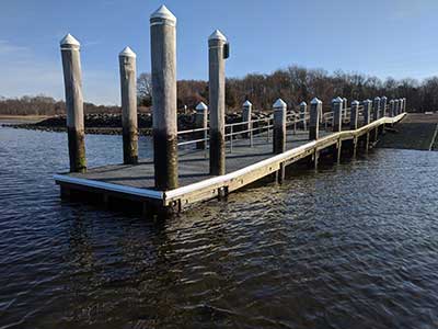
The Dock After Being Rebuilt in 2020
Photography by: Geoff Dennis
Do you have comments, corrections or additions to the information about this site?
Help us work together to make this website better by sharing your knowledge!


Private feedback goes to the Blueways Alliance/RI Land Trust Council. We'll use your information to make this website better or pass it along to the people who can deal with physical issues at this site. Public comments are posted here (once they've been reviewed and approved) for all to see.
The data on this website come from many sources, including volunteers and organizations across the state of Rhode Island and nearby parts of Massachusetts. We have done our best to make sure the data are accurate and up to date, but any information critical to the success of your trip should be confirmed before you start. The maps and information on this website should not be substituted for nautical charts, topographic maps, or other more detailed maps and guides. We welcome corrections and additions. To send a correction or provide other feedback, please use our feedback form (see link above).
This site report was last updated on June 4, 2021
Comments:
FAST AND HEAVY
Submitted by: Anonymous; October 26, 2022; 9:14 pm
BEAUTIFUL PATH IN SOME AREAS LESS CONGESTED BUT VERY CROWDED WHICH IS DANGEROUS ENOUGH BUT RECENTLY THERE IS A HUGE SPIKE IN ELECTRIC BIKES . IN CASE ANYONE IS UNSURE THOSE BIKES HAVE AN “ELECTRIC”. THERE ARE SIGNS POSTED ”NO MOTOR VEHICLES” THE BIKES ARE VERY FAST UP TO 100 LBS OR MORE. SOME CAN GO 45 mph OR MORE.
FAST AND HEAVY / RECIPE FOR DISASTER.
I WAS HIT BY A CAR LAST OCTOBER AT CHID STREET.
NOTHING GETS DONE
Rating: