

 Wilson Park
41° 34.681' N 71° 27.149' W See this location in: Google Maps Map Server Acme Maps
This is a site for launching boats from trailers. Boat ramps can normally be used to launch canoes and kayaks but please do your best to keep the boat ramp clear for boat trailers.
Description & Overview:
The boat ramp here is in fair condition and there is a good section of shoreline from which to launch hand carried boats. To launching easily-carried boats head for the marshy beach about 150 feet or so to the left (west) of the boat ramp, by the grassy area near the parking lot.
If the parking lot at the boat ramp is full there is more parking in a lot and field behind the primary lot.
Wickford Harbor is a convoluted cove with many coves and islands to explore in a kayak or other small boat making it a great place for kayaking. The waters are sheltered but boat traffic should be expected. Outside the breakwaters, Wickford Harbor opens up to the broad waters of Narragansett Bay, with Quonset Point to the north; and Rome Point, Bissel Cove, Fox Island and the Jamestown Bridge to the south. On most days the southwest wind fills in strongly in this area in the morning and blows briskly throughout the afternoon, producing strong waves once you are outside of the harbor, so be prepared for this when planning your trip.
On the nautical charts, the point the boat ramp is located on is identified as "Long Point."
This site provides access to the following water bodies: Wickford Harbor.
Location:
Alternate Site Name: Long Point, Mill Cove
Town: North Kingstown
Nearest Town Center: Wickford
Driving Landmarks: On Route 1 south, just before Wickford, you will pass a Rhode Island State Police Barracks on your right. In another 0.2 miles, turn right onto Intrepid Drive. There is a small sign for Wilson Park at this turn. Follow Intrepid Drive straight ahead to its end at the parking lot for the boat ramp. The boat ramp is at the east end of this parking lot, near a small gazebo.
Coming from the south on Route 1 north the turn onto Intrepid Drive is 0.2 miles after you pass the traffic light for West Main Street.
Access & Waters:
Water 'Features' At Site: estuary
Note: Because one boat launch can access, say, both a lake and a river or both the upstream and downstream portions of a river, not all paddling trips at a given site will necessarily encounter all of the features listed.
Type of Access: Boat ramp
ADA Accessible Boat Launch? no
Shoreline: Sandy/marshy shoreline and concrete boat ramp
Float/Dock: low float or dock
Approximate Length of Carry between Car Access and Water: 100 feet
Hours of Operation: sunrise to sunset, year round
Parking:
Parking: yes: 100 spaces, no overnight parking
ADA Accessible Parking Spaces? no
Nearby Amenities:
Public Restrooms: Yes, in the summer
Outfitter: The "Kayak Centre of Rhode Island," nearby at the corner of Brown and Phillips Streets, rents and sells kayaks and other paddling gear. See the outfitters list for more details.
Sources for More Information:
Other Guidebooks: Site 22 in Ed Mullen's book "Kayaking Narragansett Bay"
Website: Mike Krabach's kayak access website
Ecological, Cultural & Recreational Attractions:
Wilson Park is a town park with picnic tables, a playground, playing fields, basketball and tennis courts, and a short walking path that winds around Mill Cove.
Photographs:
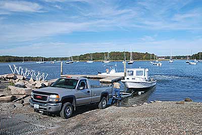
The Boat Ramp and Dock
Photography by: Tom Richardson, New England Boating
Date of Photograph: October 11, 2011
Do you have comments, corrections or additions to the information about this site?
Help us work together to make this website better by sharing your knowledge!


Private feedback goes to the Blueways Alliance/RI Land Trust Council. We'll use your information to make this website better or pass it along to the people who can deal with physical issues at this site. Public comments are posted here (once they've been reviewed and approved) for all to see.
The data on this website come from many sources, including volunteers and organizations across the state of Rhode Island and nearby parts of Massachusetts. We have done our best to make sure the data are accurate and up to date, but any information critical to the success of your trip should be confirmed before you start. The maps and information on this website should not be substituted for nautical charts, topographic maps, or other more detailed maps and guides. We welcome corrections and additions. To send a correction or provide other feedback, please use our feedback form (see link above).
This site report was last updated on March 12, 2015
Comments:
no floating docks on 5/28/18
Submitted by: Anonymous; May 29, 2018; 1:06 pm
Not sure why but there are no floating docks at this ramp. There are no signs saying when or if the docks will be repaired / replaced
[Moderator's comment: As of 6/4/2018 the docks are reportedly back in place after some maintenance work.]