

 East Greenwich Municipal Boat Ramp
41° 39.4' N 71° 26.888' W See this location in: Google Maps Map Server Acme Maps
This is a site for launching boats from trailers. Boat ramps can normally be used to launch canoes and kayaks but please do your best to keep the boat ramp clear for boat trailers.
Description & Overview:

This is the municipal boat ramp on Greenwich Cove in the center of East Greenwich. There is a wide, cement boat ramp here as well as docks and floats on both sides of the ramp and a paved parking lot. The dock and float on the south side of the ramp is wheelchair accessible.
This site provides access to Greenwich Cove, Greenwich Bay and Narragansett Bay beyond. Greenwich Cove is very sheltered but can be busy. Greenwich Bay can be rough if the wind kicks up and it can also be very busy in the summer so small boats should use caution. On most days the southwest wind fills in strongly in this area in the morning and blows throughout the afternoon, producing significant waves on Greenwich Bay, so be prepared for this when planning your trip. Most of the shoreline on the east side of Greenwich cove and on around to Sally Rock Point is Goddard Memorial State Park. (Some of the information about this site was adapted from Mike Krabach's kayak access website.)
This site provides access to the following water bodies: Greenwich Cove, Greenwich Bay, Narragansett Bay.
Location:
Alternate Site Name: Crompton Park
Town: East Greenwich
Nearest Town Center: East Greenwich
Driving Landmarks: Follow Route 401 into downtown East Greenwich. At the stop light at Route 1 go straight across Route 1 onto Rocky Hollow Road. At the stop sign turn left onto Crompton Street and look for the boat ramp on your right, next to the transfer station.
Drop off your boat and gear at the launch, and then park in the overlook/picnic area just above the launch. There are 13 parking spots here for vehicles with trailers plus about 17 spots for vehicles without trailers.
Access & Waters:
Water 'Features' At Site: estuary, ocean/bay
Note: Because one boat launch can access, say, both a lake and a river or both the upstream and downstream portions of a river, not all paddling trips at a given site will necessarily encounter all of the features listed.
Type of Access: Boat ramp
ADA Accessible Boat Launch? yes
Shoreline: Wide concrete boat ramp
Float/Dock: low float or dock
Hours of Operation: sunrise to sunset, year round
Parking:
Parking: yes: 30 spaces, no overnight parking
ADA Accessible Parking Spaces? yes
Nearby Amenities:
Public Restrooms: Yes
Sources for More Information:
Website: Mike Krabach's kayak access website
Photographs:
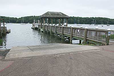
The Boat Ramp and Docks
Photography by: Tom Richardson, New England Boating
Date of Photograph: July 15, 2010
Do you have comments, corrections or additions to the information about this site?
Help us work together to make this website better by sharing your knowledge!

Private feedback goes to the Blueways Alliance/RI Land Trust Council. We'll use your information to make this website better or pass it along to the people who can deal with physical issues at this site. Public comments are posted here (once they've been reviewed and approved) for all to see.
The data on this website come from many sources, including volunteers and organizations across the state of Rhode Island and nearby parts of Massachusetts. We have done our best to make sure the data are accurate and up to date, but any information critical to the success of your trip should be confirmed before you start. The maps and information on this website should not be substituted for nautical charts, topographic maps, or other more detailed maps and guides. We welcome corrections and additions. To send a correction or provide other feedback, please use our feedback form (see link above).
This site report was last updated on March 12, 2015