

 Independence Park
41° 40.456' N 71° 16.768' W See this location in: Google Maps Map Server Acme Maps
This is a site for launching boats from trailers. Boat ramps can normally be used to launch canoes and kayaks but please do your best to keep the boat ramp clear for boat trailers.
Description & Overview:

Independence Park is a small city park in downtown Bristol, near the north end of Thames Street. There is a two lane cement slab boat ramp here that provides access to Bristol Harbor as well as a broad gravel beach suitable for launching hand-carried boats. The boat ramp is in somewhat poor condition and may be problematic for trailered boats at low tide. There is a dock with a float next to the ramp.
Bristol Harbor is a busy harbor with much to look at, but also plenty of boat traffic to watch out for. The Prudence Island Ferry runs from a dock a bit south of this put-in.
Heading out the east side of Bristol Harbor puts you under the Mount Hope Bridge, at the junction of Mount Hope Bay and the East Passage of Narragansett Bay, an area where there are likely to be lots of boats of all sizes, including freighters, tugboats and barges, as well as strong tidal currents and more wind and waves.
Heading out the west side of Bristol Harbor takes you around Poppasquash Point and then on to Colt State Park. The shoreline here is pretty, but be aware that large vessels use the shipping channel just offshore to get to the Port of Providence. The area around Poppasquash Point and on up to Colt State Park and beyond is often windy and rough.
Especially around the points and in narrow areas such as under the Mount Hope Bridge and around Poppasquash Point the tide can interact with the wind to create particularly rough conditions.
On most days the southwest wind fills in strongly throughout this area in the morning and blows through the afternoon, producing significant waves, so be prepared for this when planning your trip. Mornings are often calmer and less windy, and so are usually a better time to paddle.
This site provides access to the following water bodies: Bristol Harbor.
Location:
Town: Bristol
Nearest Town Center: Bristol, RI
Driving Landmarks: As you are approaching downtown Bristol on Route 114 south, bear right onto Thames Street and look for the park and boat ramp on your right. From Route 114 north, go through downtown Bristol and turn left onto Franklin Street, go one block and then turn right onto Thames Street. Look for the park and boat ramp on your left.
There 12 parking spaces here specifically for vehicles with trailers.
Access & Waters:
Water 'Features' At Site: estuary, ocean/bay
Note: Because one boat launch can access, say, both a lake and a river or both the upstream and downstream portions of a river, not all paddling trips at a given site will necessarily encounter all of the features listed.
Type of Access: Boat ramp
ADA Accessible Boat Launch? no
Shoreline: Gravel beach and hard surfaced boat ramp
Float/Dock: low float or dock
Hours of Operation: sunrise to sunset, year round
Parking:
Parking: yes: 60 spaces
Nearby Amenities:
Public Restrooms: There are no restrooms right at the boat ramp but at most times of day you can probably find a restroom at one of the nearby businesses in downtown Bristol.
Sources for More Information:
Website: Mike Krabach's kayak access website
Ecological, Cultural & Recreational Attractions:
Independence Park is the at the south end of the East Bay Bike Path.
Photographs:
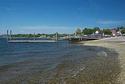
The Beach, Boat Ramp and Dock
Photography by: Tom Richardson, New England Boating
Date of Photograph: May 25, 2010
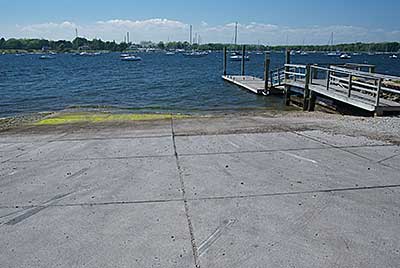
The Boat ramp and Dock
Photography by: Tom Richardson, New England Boating
Date of Photograph: May 25, 2010
Note that this picture is from 2010. The condition of the ramp has deteriorated since then.
Do you have comments, corrections or additions to the information about this site?
Help us work together to make this website better by sharing your knowledge!

Private feedback goes to the Blueways Alliance/RI Land Trust Council. We'll use your information to make this website better or pass it along to the people who can deal with physical issues at this site. Public comments are posted here (once they've been reviewed and approved) for all to see.
The data on this website come from many sources, including volunteers and organizations across the state of Rhode Island and nearby parts of Massachusetts. We have done our best to make sure the data are accurate and up to date, but any information critical to the success of your trip should be confirmed before you start. The maps and information on this website should not be substituted for nautical charts, topographic maps, or other more detailed maps and guides. We welcome corrections and additions. To send a correction or provide other feedback, please use our feedback form (see link above).
This site report was last updated on March 12, 2015