


 Manville - Below Dam
41° 58.151' N 71° 27.905' W See this location in: Google Maps Map Server Acme Maps
This is a site for launching hand-carried boats and it is also a portage. This typically means that to continue paddling down the river past this site you will have to portage your boat around a dam or other obstruction.
Description & Overview:

The Blackstone River below Manville flows between natural, wooded banks that are quite pretty for the most part. The river between Manville and Albion is largely flatwater but there is one section of quickwater. It is 1.3 miles to the Albion Dam where there is a relatively easy portage.
If you have driven to the bike path parking lot, as described below in the driving directions, then to get to the river look for a building on the right called "Sycamore Landing," just past the parking lot. Just beyond this building is iron gate on the right side of the road and a path running next to a wooden fence from this gate down to the river. You can unload your boat and gear near the gate but then you must move your car back to the parking lot. To get to the river follow the path straight to the river.
If you are paddling down the river to Manville and want to continue down the river below Manville you face a long portage. Take out above the Manville Dam at the small path on river right where there are stairs leading up to the bike path. Carry along the bike path past the dam for 1/3 mile until you get to the parking lot for the bike path. Follow the directions above for getting from here to the river.
If you are paddling down the river and plan to take out at Manville you are better off using the boat landing above the dam on river left, which is listed separately as Manville - Above Dam.
This site provides access to the following water bodies in the Blackstone River watershed: Blackstone River.
Location:
Town: Lincoln
Driving Landmarks: From I-295 take exit 10 for Route 122 north towards Cumberland. This will put you on Route 122 (Mendon Road). Go 2 1/2 miles and turn left on Manville Hill Road at Poppy's Family Restaurant. Go 1 mile down the hill and turn left at the light just after you cross the river. This will put you on New River Road heading south (note: the sign at the traffic light may say Railroad Street because turning right at this light puts you on Railroad Street). Go 0.1 miles and turn left at the purple sign for the Blackstone River Bikeway. Cross the railroad tracks and continue on to the parking lot for the bike path. See the description above for more details on how to get to the river from here.
From Route 99, turn right where Route 99 dead ends into Route 122 (Mendon Road). Go 1 1/4 miles south on Route 122 and turn right onto Manville Hill Road at Poppy's Family Restaurant. Go 1 mile down the hill and turn left at the light just after you cross the river. This will put you on New River Road heading south (note: the sign at the traffic light may say Railroad Street because turning right at this light puts you on Railroad Street). Go 0.1 miles and turn left at the purple sign for the Blackstone River Bikeway. Cross the railroad tracks and continue on to the parking lot for the bike path. See the description above for more details on how to get to the river from here.
Access & Waters:
Water 'Features' At Site: dam, flatwater/slow moving river
Note: Because one boat launch can access, say, both a lake and a river or both the upstream and downstream portions of a river, not all paddling trips at a given site will necessarily encounter all of the features listed.
Type of Access: Boat launch for hand carried boats
ADA Accessible Boat Launch? no
Shoreline: A nice sandy beach good for launching hand carried boats
Float/Dock: no
Approximate Length of Carry between Car Access and Water: 350 feet
Portage Length: 2500 feet
Parking:
Parking: yes: 16 spaces
ADA Accessible Parking Spaces? yes
Sources for More Information:
Other Guidebooks: Paddle 31 in "Paddling Connecticut and Rhode Island"
Website: Blackstone Heritage Corridor website: "Get on the River" page
Ecological, Cultural & Recreational Attractions:
The Blackstone River Bikeway runs right past this site and provides a nice walking and biking trail.
Photographs:
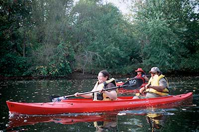
Paddling on the Blackstone River between Manville and Albion
Photography by: Bruce Hooke
Date of Photograph: October 3, 2007
Do you have comments, corrections or additions to the information about this site?
Help us work together to make this website better by sharing your knowledge!

Private feedback goes to the Blueways Alliance/RI Land Trust Council. We'll use your information to make this website better or pass it along to the people who can deal with physical issues at this site. Public comments are posted here (once they've been reviewed and approved) for all to see.
The data on this website come from many sources, including volunteers and organizations across the state of Rhode Island and nearby parts of Massachusetts. We have done our best to make sure the data are accurate and up to date, but any information critical to the success of your trip should be confirmed before you start. The maps and information on this website should not be substituted for nautical charts, topographic maps, or other more detailed maps and guides. We welcome corrections and additions. To send a correction or provide other feedback, please use our feedback form (see link above).
This site report was last updated on July 1, 2012