

 School Street Pier/Festival Pier
41° 52.169' N 71° 22.818' W See this location in: Google Maps Map Server Acme Maps
This is a site for launching boats from trailers. Boat ramps can normally be used to launch canoes and kayaks but please do your best to keep the boat ramp clear for boat trailers.
Description & Overview:

After a $2 million rebuild completed in 2015 this site is now greatly improved. There's a new boat ramp with extensive docking space adjacent to the ramp. On land there's also a nice park with picnic tables and a large plaza overlooking the river. The site is popular for fishing but can also be used to launch trailered and hand carried boats into the Seekonk River. If launching hand-carried boats from the boat ramp please do your best to keep the ramp clear for trailered boats. This busy ramp can be a challenging place to launch a kayak due to the lack of shoreline access adjacent to the ramp.
Depending on the tide there can also be a significant current past this ramp and the adjacent docks.
The Seekonk River is a long tidal estuary that starts where the Blackstone River ends in downtown Pawtucket and continues down between Providence and East Providence until it joins the Providence River in Providence Harbor. The convoluted shoreline provides some good potential for exploration in a small boat as long as you pay attention to the wind and tides. The tide runs hard through the narrows at the south end of the Seekonk, too hard to paddle against at times, and it is a complex current that does not always flow in the direction you would expect given the state of the tide. However, there are 3 miles of river to explore between this boat ramp and the narrows, so you can stay clear of the narrows and still do quite a bit of paddling.
This site provides access to the following water bodies: Seekonk River.
Location:
Alternate Site Name: Old State Pier
Town: Pawtucket
Nearest Town Center: Pawtucket
Driving Landmarks: From I-95 North (e.g., coming from Providence) take exit 28 for School Street. Bear right at the fork in the ramp, which will put you on School Street south. Go 3/10 mile south on School Street and look for a turn off on the right leading down to the park. In 650 feet this road takes a sharp bend to the right and continues down to the park and boat ramp.
From I-95 South take Exit 29 for Broadway and downtown Pawtucket. The ramp is long but it will eventually put you on Broadway headed south. Go a half mile south on Broadway. As you are approaching the bridge over the Blackstone River, turn left onto Main Street. Go 400 feet up Main Street and turn right onto Water Street. Go 1/2 mile south on Water Street (it will merge with School Street) and look for a turn off on the right leading down to the park. In 650 feet this road takes a sharp bend to the right and continues down to the park and boat ramp.
Access & Waters:
Water 'Features' At Site: estuary
Note: Because one boat launch can access, say, both a lake and a river or both the upstream and downstream portions of a river, not all paddling trips at a given site will necessarily encounter all of the features listed.
Type of Access: Boat ramp
ADA Accessible Boat Launch? no
Shoreline: Hard surface boat ramp
Float/Dock: low float or dock
Parking:
Parking: yes: 70 spaces
ADA Accessible Parking Spaces? yes
Photographs:
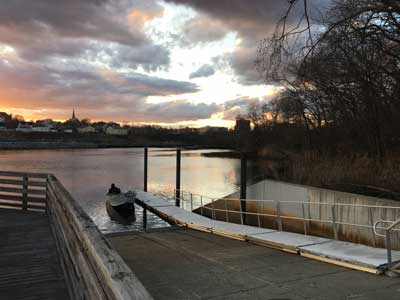
The Boat Ramp and Dock
Photography by: Bruce Hooke
Date of Photograph: April 8, 2022

The Boat Ramp and Dock
Photography by: Bruce Hooke
Date of Photograph: April 8, 2022
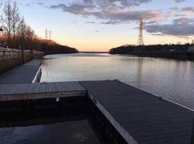
The Additional Dock Space South of the Ramp
Photography by: Bruce Hooke
Date of Photograph: April 7, 2022
Do you have comments, corrections or additions to the information about this site?
Help us work together to make this website better by sharing your knowledge!

Private feedback goes to the Blueways Alliance/RI Land Trust Council. We'll use your information to make this website better or pass it along to the people who can deal with physical issues at this site. Public comments are posted here (once they've been reviewed and approved) for all to see.
The data on this website come from many sources, including volunteers and organizations across the state of Rhode Island and nearby parts of Massachusetts. We have done our best to make sure the data are accurate and up to date, but any information critical to the success of your trip should be confirmed before you start. The maps and information on this website should not be substituted for nautical charts, topographic maps, or other more detailed maps and guides. We welcome corrections and additions. To send a correction or provide other feedback, please use our feedback form (see link above).
This site report was last updated on April 18, 2022