


 River Island Park
41° 59.977' N 71° 30.814' W See this location in: Google Maps Map Server Acme Maps
This is a site for launching hand-carried boats and it is also a portage. This typically means that to continue paddling down the river past this site you will have to portage your boat around a dam or other obstruction.
Description & Overview:

River Island Park is a good place to put into the Blackstone River for a paddle through Woonsocket and on down to Manville and beyond. Coming downstream from ABOVE here there is a 3/4 mile portage around the Thundermist Dam, this access site being the end of that portage, so there is little merit in putting in above here until you get above the Blackstone Gorge and into Massachusetts. Heading downstream from here there is a mix of flatwater and class I-II whitewater so this section is best for more experienced paddlers, especially at normal or higher river levels. At very low river levels (around 0.8 feet and below on the USGS Woonsocket River Gauge) the paddling is easier but so rocky that it is only suitable for tough, light boat such as small kayaks. Scenically, the first section of the river below here, through downtown Woonsocket, speaks to the industrial past and present of this part of Rhode Island, however once you get through downtown Woonsocket, which does not take long, the banks become tree-lined and the views more scenic. The first portage is just over 4 miles downriver at the Manville Dam, which can also be a take out.
This site provides access to the following water bodies in the Blackstone River watershed: Blackstone River.
Location:
Town: Woonsocket
Nearest Town Center: Woonsocket
Driving Landmarks: From Route 146 north, a little north of the junction with I-295 and just past the light at Sayles Hill Road, look for a fork to the right leading to 146A. Take the this fork and follow 146A north for 1.2 miles and turn right onto Park Avenue. Go 1.2 miles and turn left onto Bernon Street. In 1/4 mile, just after you cross the river, look for a parking lot on the left for River Island Park.
Access & Waters:
Water 'Features' At Site: whitewater, flatwater/slow moving river
Note: Because one boat launch can access, say, both a lake and a river or both the upstream and downstream portions of a river, not all paddling trips at a given site will necessarily encounter all of the features listed.
Type of Access: Boat launch for hand carried boats
ADA Accessible Boat Launch? no
Shoreline: Sandy
Float/Dock: no
Approximate Length of Carry between Car Access and Water: 100 feet
Portage Length: 4000 feet
Parking:
Parking: yes: 16 spaces, no overnight parking
ADA Accessible Parking Spaces? no
Sources for More Information:
Website: USGS River Gauge on the Blackstone River at Woonsocket
Photographs:
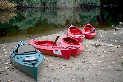
The boat launch at River Island Park
Photography by: Bruce Hooke
Date of Photograph: October 3, 2007
This is what the shoreline looks like at River Island Park when the river is low.
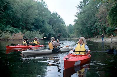
The Blackstone at River Island Park
Photography by: Bruce Hooke
Date of Photograph: October 3, 2007
This is what the Blackstone River looks like at River Island Park when the river is low. This view is looking upstream and the boat launch is on the right where the people are standing on the shore.
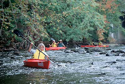
Quickwater in Woonsocket
Photography by: Bruce Hooke
Date of Photograph: October 3, 2007
Paddlers working through the quickwater in Woonsocket. This is what the river looks like when the water levels are very low.
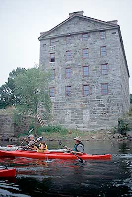
Paddling past a Historic Mill in Woonsocket
Photography by: Bruce Hooke
Date of Photograph: October 3, 2007
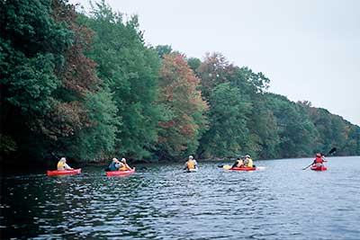
The Blackstone River below Woonsocket
Photography by: Bruce Hooke
Date of Photograph: October 3, 2007
Below Woonsocket the river becomes wider and quieter and the banks are wooded.
Do you have comments, corrections or additions to the information about this site?
Help us work together to make this website better by sharing your knowledge!

Private feedback goes to the Blueways Alliance/RI Land Trust Council. We'll use your information to make this website better or pass it along to the people who can deal with physical issues at this site. Public comments are posted here (once they've been reviewed and approved) for all to see.
The data on this website come from many sources, including volunteers and organizations across the state of Rhode Island and nearby parts of Massachusetts. We have done our best to make sure the data are accurate and up to date, but any information critical to the success of your trip should be confirmed before you start. The maps and information on this website should not be substituted for nautical charts, topographic maps, or other more detailed maps and guides. We welcome corrections and additions. To send a correction or provide other feedback, please use our feedback form (see link above).
This site report was last updated on June 17, 2008