


 Albion
41° 57.188' N 71° 27.164' W See this location in: Google Maps Map Server Acme Maps
This is a site for launching hand-carried boats and it is also a portage. This typically means that to continue paddling down the river past this site you will have to portage your boat around a dam or other obstruction.
Description & Overview:

This is possibly the most scenic section of the Blackstone in Rhode Island. The river runs in a deep valley here and the banks are largely wooded and natural.
There is good access to the river for launching hand-carried boats about 150 feet up the bike path from the upper parking lot. Look for steps leading down to the river below the dam.
Paddling downriver from here the river is pretty and relatively quiet. Much of this section of the river is within Blackstone State Park. In 1 mile you will come to the I-295 overpass, and in another 1/3 mile you will come to the Ashton Dam, which must be portaged on river right. For more details see the description for the "Blackstone River State Park" boat launch.
If you are paddling down the Blackstone from above Albion, look for a take out on river right about 75 feet before the dam. There is a nice little gravel slope and a short path leading up to the bike path. Take out here and carry about 250 feet down the bike path to the steps leading to the river below the dam.
This site provides access to the following water bodies in the Blackstone River watershed: Blackstone River.
Location:
Town: Lincoln
Driving Landmarks: From I-295 take exit 10 for Route 122 north towards Cumberland. This will put you on Route 122 (Mendon Road). After a short distance on Mendon Road, turn left at the CVS store onto Albion Road and go 0.7 miles. Just after you cross the iron bridge over the river, turn left or right into the parking lots for Blackstone State Park.
Access & Waters:
Water 'Features' At Site: dam, whitewater, flatwater/slow moving river
Note: Because one boat launch can access, say, both a lake and a river or both the upstream and downstream portions of a river, not all paddling trips at a given site will necessarily encounter all of the features listed.
Type of Access: Boat launch for hand carried boats
Shoreline: Sand and gravel
Float/Dock: no
Approximate Length of Carry between Car Access and Water: 150 feet
Portage Length: 300 feet
Parking:
Parking: yes: 12 spaces
ADA Accessible Parking Spaces? yes
Sources for More Information:
Other Guidebooks: Paddle 31 in "Paddling Connecticut and Rhode Island"
Ecological, Cultural & Recreational Attractions:
The Blackstone Valley Bikeway runs right past this site.
Photographs:
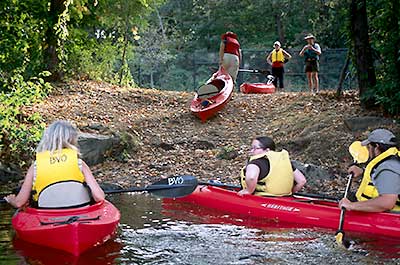
Take out above Albion Dam
Photography by: Bruce Hooke
Date of Photograph: October 3, 2007
The take out above the Albion Dam.
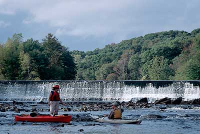
Below Albion Dam
Photography by: Bruce Hooke
Date of Photograph: October 3, 2007
This is what the river looks like just below Albion Dam when the river is quite low. This section of the river can be avoided by carrying a bit further down the bike path.
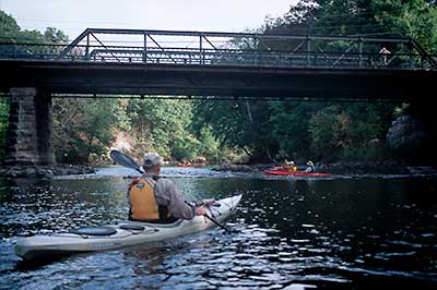
Paddling under the Albion Bridge
Photography by: Bruce Hooke
Date of Photograph: October 3, 2007
Paddling under the historic truss bridge at Albion
Do you have comments, corrections or additions to the information about this site?
Help us work together to make this website better by sharing your knowledge!

Private feedback goes to the Blueways Alliance/RI Land Trust Council. We'll use your information to make this website better or pass it along to the people who can deal with physical issues at this site. Public comments are posted here (once they've been reviewed and approved) for all to see.
The data on this website come from many sources, including volunteers and organizations across the state of Rhode Island and nearby parts of Massachusetts. We have done our best to make sure the data are accurate and up to date, but any information critical to the success of your trip should be confirmed before you start. The maps and information on this website should not be substituted for nautical charts, topographic maps, or other more detailed maps and guides. We welcome corrections and additions. To send a correction or provide other feedback, please use our feedback form (see link above).
This site report was last updated on September 25, 2012