

 Misquamicut State Beach
41° 19.519' N 71° 48.159' W See this location in: Google Maps Map Server Acme Maps
This is a site for launching hand-carried boats such as canoes or kayaks.
Description & Overview:

This site provides the only public access to the 470 acre Winnapaug Pond. If you don't mind the dirt path and the puddles getting there, the shoreline at the end of the path is sandy and good for launching small boats and Winnapaug Pond is a great place for a gentle paddle. The pond is best for paddling in the spring and the fall when Jet Skis are less common. The pond is quite shallow so larger boats are less common. At the far end of the pond, about 1 1/2 miles from the boat launch, is the start of the channel leading out to the sea. Watch out for strong currents in this area and don't get pulled into the rock lined channel. Only expert paddlers should even consider going out the channel to the open ocean. Breachways such as this can easily be closed even to large boats by breakers as the wind picks up or even just as a result of a change in the tide, leaving no way to back shore. However, there are plenty of interesting coves to explore within the pond without getting into the outlet channel.
On most days the southwest wind fills in across this area in the morning and blows throughout the afternoon, so be prepared for this when planning your trip.
This site provides access to the following water bodies in the Coastal Watersheds (West Bay) watershed: Winnapaug Pond.
Location:
Alternate Site Name: Winnapaug Pond
Town: Westerly
Nearest Town Center: Westerly
Driving Landmarks: From Route 1 in Westerly, follow the signs to Misquamicut State Beach on Atlantic Avenue. Across Atlantic Avenue from the Misquamicut State Beach parking lot there is a dirt pull-out at telephone pole #106. From the back of this pull-out there is a rough dirt road/path to the pond. This path is frequently flooded at high tides and so may be wet at times. You can unload your boats and gear at this pull-out but you must park in the state beach parking lot across the road.
Access & Waters:
Water 'Features' At Site: estuary
Note: Because one boat launch can access, say, both a lake and a river or both the upstream and downstream portions of a river, not all paddling trips at a given site will necessarily encounter all of the features listed.
Type of Access: Boat launch for hand carried boats
ADA Accessible Boat Launch? no
Shoreline: Sand and mud
Float/Dock: no
Approximate Length of Carry between Car Access and Water: 500 feet
Hours of Operation: sunrise to sunset
Fees: Yes, during beach season. See the Misquamicut State Beach website for rates.
Parking:
Parking: yes: 1400 spaces, no overnight parking
ADA Accessible Parking Spaces? yes
Nearby Amenities:
Public Restrooms: Yes, in season at state beach.
Accomodations: There are many places to stay in the area. Most are seasonal.
Sources for More Information:
Other Guidebooks: Salt Ponds Coalition Kayaker's Guide
Website: Salt Ponds Coalition Kayaker's Guide to the Salt Ponds of South County, Rhode Island
Website: Misquamicut State Beach (see this website for parking information)
Ecological, Cultural & Recreational Attractions:
Misquamicut Beach is one of the largest and most popular public beaches in the state. There is over half a mile of beach front within the State Beach.
Photographs:
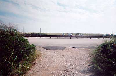
The start of the path to the shore at Winnepaug Pond
Photography by: Art Ganz and Bambi Poppick
Date of Photograph: September 6, 2006
This photo shows the start of the path leading to Winnepaug Pond. Atlantic Avenue and the parking lot for the state beach are in the background.
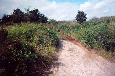
Path to Winnepaug Pond
Photography by: Art Ganz and Bambi Poppick
Date of Photograph: September 6, 2006
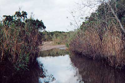
The End of the Path at Winnepaug Pond
Photography by: Art Ganz and Bambi Poppick
Date of Photograph: September 6, 2006
This is a view from the water of the boat launching area at the end of the path to Winnepaug Pond.
Do you have comments, corrections or additions to the information about this site?
Help us work together to make this website better by sharing your knowledge!

Private feedback goes to the Blueways Alliance/RI Land Trust Council. We'll use your information to make this website better or pass it along to the people who can deal with physical issues at this site. Public comments are posted here (once they've been reviewed and approved) for all to see.
The data on this website come from many sources, including volunteers and organizations across the state of Rhode Island and nearby parts of Massachusetts. We have done our best to make sure the data are accurate and up to date, but any information critical to the success of your trip should be confirmed before you start. The maps and information on this website should not be substituted for nautical charts, topographic maps, or other more detailed maps and guides. We welcome corrections and additions. To send a correction or provide other feedback, please use our feedback form (see link above).
This site report was last updated on June 5, 2011