

 Boyden Refuge Canoe/Kayak Launch
41° 52.865' N 71° 7.76' W See this location in: Google Maps Map Server Acme Maps
This is a site for launching hand-carried boats such as canoes or kayaks.
Description & Overview:

The canoe/kayak launch at Gertrude Boyden Refuge provides access to a pretty section of the Three Mile River, where the river is backed up by a dam that has resulted in the development of a pretty wetland, popular with birds and other wildlife as well as with paddlers and fisherman.
To get to the put-in from the parking area, walk about 100 feet further down the paved road and then turn right onto a broad gravel path. Follow this path about 300 feet downhill to the "river." Calling the water here a river is a bit misleading. While it is narrow and winding like a river, the dam a mile downriver means that there is almost no current to deal with. So, you can paddle "upriver" just as easily as you can paddle "downriver."
Just upriver (right) from the put-in there used to be some large trees down across the river but in the spring of 2012 these trees were cleared away thanks to help from Lopes Construction, which donated some crane time, and donated time by police divers from Taunton and several other communities. So, now it is easy to paddle upriver from the put-in. You can paddle about 1/2 mile upriver before the river will either get too shallow to paddle up or the current will become too strong to paddle against, depending on the river level.
Heading downriver (left) from the put-in the river slowly opens out into a broad marsh, with various coves and side channels, most of which are filled with water lilies and other wetland plants.
When you start seeing buildings ahead, you have reached the south end of the pond. Be careful near the dam on the east side of the pond near the south end so you do not paddle over it! Paddling downriver on the Three Mile River below this dam is not recommended. If you want to see more of the Three Mile you can paddle upriver for some distance from the junction with the Taunton River (put in at Weir Village Park or Berkley Bridge).
This site provides access to the following water bodies in the Taunton River watershed: Three Mile River.
Location:
Alternate Site Name: Gertrude Boyden Wildlife Refuge
Town: Taunton
Nearest Town Center: Taunton
Driving Landmarks: From US 44 head south on (Joseph E.) Warner Boulevard. The turn off 44 is at a traffic light about 1.5 miles west of the center of Taunton. There is a CVS on the corner and a Shaw's Supermarket behind it. Go 0.2 miles south on Warner Boulevard and turn right onto Cohannet Street. The entrance to the refuge is 0.4 miles ahead on the left, at 1298 Cohannet Street. Turn left into the refuge and go 0.15 miles to the parking area.
Access & Waters:
Water 'Features' At Site: flatwater/slow moving river, pond
Note: Because one boat launch can access, say, both a lake and a river or both the upstream and downstream portions of a river, not all paddling trips at a given site will necessarily encounter all of the features listed.
Type of Access: Boat launch for hand carried boats
ADA Accessible Boat Launch? no
Shoreline: Sand and some mud
Float/Dock: no
Approximate Length of Carry between Car Access and Water: 400 feet
Hours of Operation: 9am to sunset
Parking:
Parking: yes: 20 spaces, no overnight parking
ADA Accessible Parking Spaces? yes
Nearby Amenities:
Public Restrooms: There may be restrooms available in the building beside the parking lot but currently it's not clear whether and during what hours these restrooms are available to the public.
Ecological, Cultural & Recreational Attractions:
Gertrude Boyden Refuge is a 52-acre city park beside the Three Mile River in Taunton. There are trails, picnic tables and BBQ grills, and fishing in the river is popular, both from boats and from the riverbanks.
Photographs:
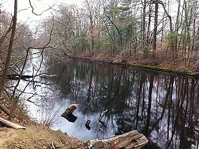
View Downstream from near the Canoe/Kayak Launch
Photography by: Jen O'Keefe
Date of Photograph: April 2, 2012
This is a view looking down the Three Mile River from about 200 feet above the canoe/kayak launch, near where the trees were removed from the river. The launch is on the left.
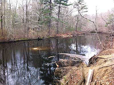
View Upstream from near the Canoe/Kayak Launch
Photography by: Jen O'Keefe
Date of Photograph: April 2, 2012
This is a view looking up the Three Mile River from about 200 feet above the canoe/kayak launch, near where the trees were removed from the river. The sand bar visible in the photograph was created by the fallen trees and will likely wash away in time.
Do you have comments, corrections or additions to the information about this site?
Help us work together to make this website better by sharing your knowledge!

Private feedback goes to the Blueways Alliance/RI Land Trust Council. We'll use your information to make this website better or pass it along to the people who can deal with physical issues at this site. Public comments are posted here (once they've been reviewed and approved) for all to see.
The data on this website come from many sources, including volunteers and organizations across the state of Rhode Island and nearby parts of Massachusetts. We have done our best to make sure the data are accurate and up to date, but any information critical to the success of your trip should be confirmed before you start. The maps and information on this website should not be substituted for nautical charts, topographic maps, or other more detailed maps and guides. We welcome corrections and additions. To send a correction or provide other feedback, please use our feedback form (see link above).
This site report was last updated on May 12, 2017