

 Titicut Street Bridge
41° 56.032' N 70° 57.411' W See this location in: Google Maps Map Server Acme Maps
This is a site for launching hand-carried boats such as canoes or kayaks.
Description & Overview:

The Titicut Street Bridge provides fairly good access to the Taunton River a mile below its junction with the Nemasket River. The best put-in/take-out at Titicut Street is on river left on the downriver side of the bridge, but there is also a place where you can take-out on river left just before the bridge. The path down to the launch below the bridge is short but a bit steep. Once at the riverbank there is a nice sloping area from which to launch canoes and kayaks (but this area may be underwater at higher river levels).
There is a short section of Class I rapids under the bridge. If you are putting in here to go downriver you do not need to run these rapids, however, if you are paddling down river to Titicut Street you will need to run the rapids to get to the usual take out below the bridge. When the USGS Stream Gage (see link below) is showing a river gage height of around 3.5 feet these rapids are a bit rocky and it is easy to get hung up on rocks, which can tip your boat over if you are not careful. At gage heights of 4 to 4.5 feet there should be enough water to avoid the rocks if you are careful but the waves will be bigger. At even higher river levels the rapids reportedly tend to wash out and are in fact easier to run. When the gage height is in the range of 3.5 feet there are rocks exposed on either side of the river under the bridge that you can walk on to get around the rapids.
Below Titicut Street the Taunton River is largely broad and slow moving all the way to Taunton (and beyond), however, there are two short Class I rapids: at Green Street (Sturtevant Bridge) and Vernon Street (Pratts Bridge) (1.8 and 2.3 miles below Titicut Street). Another hazard to be aware of, especially below Route 44, is rocks just below the surface of the river. These rocks are usually visible but often hard to see since the river is moving so slowly that the rocks do not create any ripples on the surface of the river. If you hit one at just the right angle it could flip your boat.
Below Titicut Street it is almost 8 miles to the next take-out, at the South Street East Bridge, but there are various bridges along the way where one could manage to take out in an emergency. Other than these bridges the riverbanks are largely cloaked with a deep, mature forest with occasional pastures running down to the river but few other signs of civilization.
Below the rapids at Pratts Bridge, 2.3 miles below Titicut Street, the river starts to become tidal so you can expect the river to rise and fall throughout the day. So, when pulling boats up onto the shore, make sure they are far enough up that a rising tide will not float them off and to be safe, tie them to something secure. By the time the river gets to Taunton this rise and fall can approach 4 feet.
This site provides access to the following water bodies in the Taunton River watershed: Taunton River.
Location:
Town: Bridgewater
Nearest Town Center: Bridgewater and Middleborough Centers
Driving Landmarks: From MA Routes 18 and 28 (Bedford Street), 2.2 miles north of the traffic circle at Route 44, go east on Plymouth Street (i.e., turn right if you are coming from the traffic circle). Go 0.3 miles on Plymouth Street and turn left on Titicut Street. The river is 0.2 miles ahead on Titicut Street. Park where there is space along the sides of the road but watch out for the metal rods (from old concrete posts) sticking up but hidden in the grass along the side of the road. The best put-in and take-out is on the south side of the river (river left) on the east (downriver) side of the bridge. There is slightly better parking a bit back from the bridge on the north side of the river.
Access & Waters:
Water 'Features' At Site: whitewater, flatwater/slow moving river
Note: Because one boat launch can access, say, both a lake and a river or both the upstream and downstream portions of a river, not all paddling trips at a given site will necessarily encounter all of the features listed.
Type of Access: Boat launch for hand carried boats
ADA Accessible Boat Launch? no
Shoreline: Earth and roots
Float/Dock: no
Approximate Length of Carry between Car Access and Water: 50 feet
Parking:
Parking: on street, 6 spaces
ADA Accessible Parking Spaces? no
Nearby Amenities:
Public Restrooms: No
Sources for More Information:
AMC River Guide: 4th Edition, page 153
Website: USGS Stream Gage at Titicut Street
Photographs:
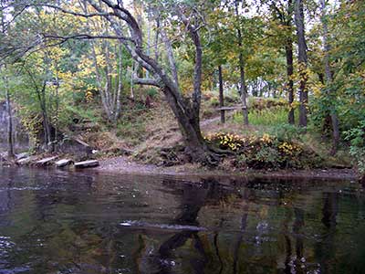
The Path to the River at Titicut Street
Photography by: Jessica Schultz
Date of Photograph: October 4, 2008
A view of the path down to the river at Titicut Street (looking up river). The bridge is just out of the picture on the left.
Do you have comments, corrections or additions to the information about this site?
Help us work together to make this website better by sharing your knowledge!

Private feedback goes to the Blueways Alliance/RI Land Trust Council. We'll use your information to make this website better or pass it along to the people who can deal with physical issues at this site. Public comments are posted here (once they've been reviewed and approved) for all to see.
The data on this website come from many sources, including volunteers and organizations across the state of Rhode Island and nearby parts of Massachusetts. We have done our best to make sure the data are accurate and up to date, but any information critical to the success of your trip should be confirmed before you start. The maps and information on this website should not be substituted for nautical charts, topographic maps, or other more detailed maps and guides. We welcome corrections and additions. To send a correction or provide other feedback, please use our feedback form (see link above).
This site report was last updated on August 29, 2010