

 Fisherville
42° 10.609' N 71° 41.3' W See this location in: Google Maps Map Server Acme Maps
This is a site for launching hand-carried boats such as canoes or kayaks.
Description & Overview:

This site provides access to the Blackstone River a little below the Fisherville Dam. Park in the parking lot for the Mill Villages Park. Right next to the parking lot is a section of the old canal, or possibly an old talerace from the mill that used to stand across the street. However, to get to the river you will have to walk a bit more. Go to the picnic shelter and from there look for a dirt path leading down into the scrubby woods near the river. In about 250 feet you should see a simple, gray bench on the left. One possible put-in is just behind this bench. Another is a little further down the path. Which is best will depend on the river level and the state of the vegetation.
The river below here is a mix of flatwater and occasional quickwater, with some Class I whitewater. 0.6 miles below Fisherville there is a difficult portage in Farnumsville, above the Depot Street Bridge, around an old wooden dam.
The riverbanks below Fisherville alternate between clusters of houses and mill buildings and long stretches where the banks are wooded and rural.
For paddling this section of the Blackstone a more detailed guide is necessary then this website can provide. You should use the AMC River Guide or a similar book and only paddle this section of the river if you are an experienced paddler.
Note that in the sources for more information below, the Blackstone Heritage Corridor website has good general information about paddling on the Blackstone, but their excellent maps do not cover this part of the river yet. Their first map starts at Plummer's Landing, 5 miles down the river from Fisherville.
NOTE: There are ongoing issues with pollution in the Blackstone River. Great strides have been made in cleaning up the river relative to where it was a generation or two ago but under some conditions the water may still have a noticeable odor.
This site provides access to the following water bodies in the Blackstone River watershed: Blackstone River.
Location:
Alternate Site Name: Main Street, Grafton
Town: Grafton
Nearest Town Center: Grafton, MA
Driving Landmarks: This put-in is right on Route 122A in Grafton, 0.5 miles west of the junction with Route 122. Park in the parking lot for the Mill Villages Park on the west side of the river.
Access & Waters:
Water 'Features' At Site: dam, whitewater, flatwater/slow moving river
Note: Because one boat launch can access, say, both a lake and a river or both the upstream and downstream portions of a river, not all paddling trips at a given site will necessarily encounter all of the features listed.
Type of Access: Boat launch for hand carried boats
ADA Accessible Boat Launch? no
Shoreline: Sand and gravel
Float/Dock: no
Approximate Length of Carry between Car Access and Water: 350 feet
Parking:
Parking: yes: 30 spaces
ADA Accessible Parking Spaces? no
Sources for More Information:
AMC River Guide: 4th edition pages 150-151
Website: Blackstone Heritage Corridor National Park - Get On the River Page
Photographs:
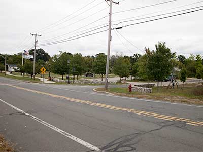
Mill Villages Park
Photography by: Bruce Hooke
Date of Photograph: September 18, 2020
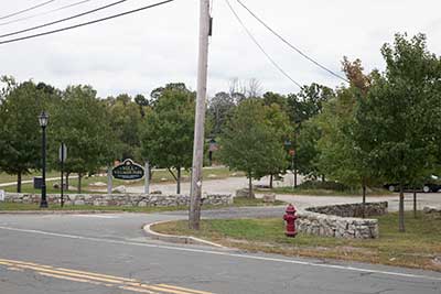
The Entrance to the Parking Lot at Mill Villages Park
Photography by: Bruce Hooke
Date of Photograph: September 18, 2020
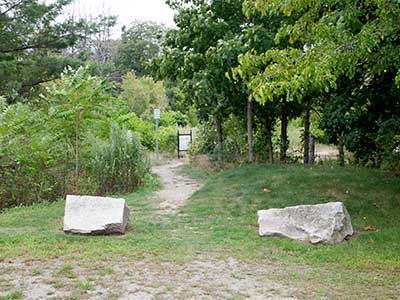
The Path to the River from near the Picnic Shelter
Photography by: Bruce Hooke
Date of Photograph: September 18, 2020
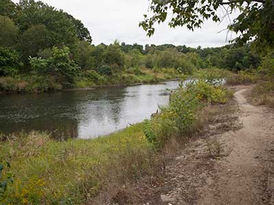
One Possible Put-In
Photography by: Bruce Hooke
Date of Photograph: September 18, 2020
Note that this photograph was made in September, during a drought. The river is usually higher than this here.
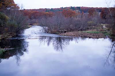
View Down River from Fisherville
Photography by: Bruce Hooke
Date of Photograph: November 3, 2008
This is a view downriver from the bridge at Fisherville. The put-in is beyond the screen of small trees in the center of this photograph.
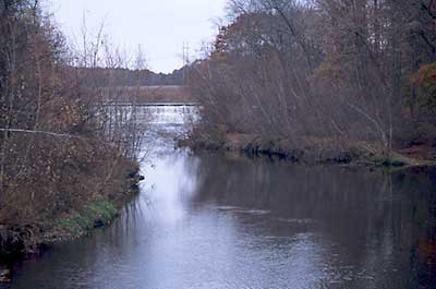
View Up River Towards the Fisherville Dam
Photography by: Bruce Hooke
Date of Photograph: November 3, 2008
This view up river from the bridge at Fisherville shows the Fisherville Dam, which must be portaged if you are coming down river to Fisherville.
Do you have comments, corrections or additions to the information about this site?
Help us work together to make this website better by sharing your knowledge!

Private feedback goes to the Blueways Alliance/RI Land Trust Council. We'll use your information to make this website better or pass it along to the people who can deal with physical issues at this site. Public comments are posted here (once they've been reviewed and approved) for all to see.
The data on this website come from many sources, including volunteers and organizations across the state of Rhode Island and nearby parts of Massachusetts. We have done our best to make sure the data are accurate and up to date, but any information critical to the success of your trip should be confirmed before you start. The maps and information on this website should not be substituted for nautical charts, topographic maps, or other more detailed maps and guides. We welcome corrections and additions. To send a correction or provide other feedback, please use our feedback form (see link above).
This site report was last updated on September 21, 2020