

 Howard Conservation Area Canoe Launch
41° 43.91' N 71° 27.619' W See this location in: Google Maps Map Server Acme Maps
This is a site for launching hand-carried boats such as canoes or kayaks.
Description & Overview:
NOTE: As of the middle of June 2026 the parking lot is reportedly blocked off with sand bags.
This put-in, built in 2008 by the Pawtuxet River Authority and extensively repaired in 2018 and 2019 after some flood damage, provides access to the Pawtuxet River 6 1/2 miles above Rhodes on the Pawtuxet, where you can take out. With the 2011 removal of the dam at the mouth of the river you can also paddle out of the river into Pawtuxet Cove, 1/3 mile below Rhodes on the Pawtuxet, as long as you time the tides right. For more very important details about the area at the mouth of the river see the description for the put-in at Rhodes on the Pawtuxet.
At normal water levels, the paddle from Howard Conservation Area to Rhodes on the Pawtuxet is a scenic paddle on a quiet, slow-moving river, with some occasional areas of slightly faster moving water and shallows if the river is low. A wide variety of wildlife has been seen along the river here, including herons, occasional osprey, red tail hawks, cormorants, turtles, river otters, and deer. The riverbanks are wooded the entire way and the river feels surprisingly remote for a river running through a dense suburban neighborhood. You are likely to encounter some downed trees in the river but as of our last reports none should present serious problems for paddlers.
IMPORTANT: About 2 miles below the put-in and about 600 feet after the Route 37 bridges, there are the remains of an old dam or something similar in the river. These remnants are clogged with branches and should be approached with caution. It MAY be possible to run this obstruction but if you have any doubts portage past it on the sand bank at right.
If you want to, you can also paddle a mile upriver from the Howard Conservation Area put-in before you will be stopped by the dam at Pontiac Mill Falls.
2.6 miles below the put-in at Howard Conservation Area you will pass the mouth of the Pocasset River on the left. It is possible to paddle up the Pocasset for some distance.
This site provides access to the following water bodies in the Pawtuxet River watershed: Pawtuxet River.
Location:
Alternate Site Name: Knight Street Canoe Launch
Town: Warwick
Nearest Town Center: Pontiac
Driving Landmarks: From Interstate 95 north take Exit 14B for Route 37 west OR from Interstate 95 south take Exit 14 for Route 37 west. Once on Route 37 west, take Exit 3 for Pontiac Avenue. At the end of the ramp turn left onto Pontiac Avenue. Go 1 mile south on Pontiac Avenue and turn left to stay on Pontiac Avenue. In 0.3 miles Pontiac Avenue will turn into Knight Street. 0.2 miles ahead, Knight Street bends sharply to the right and the parking lot for the put-in is on the left at this corner.
From Interstate 295 north or south take Exit 3B for Route 37 east. Once on Route 37 east, take Exit 3 for Pontiac Avenue. At the end of the ramp bear right onto Pontiac Avenue. Go 1 mile south on Pontiac Avenue and turn left to stay on Pontiac Avenue. In 0.3 miles Pontiac Avenue will turn into Knight Street. 0.2 miles ahead, Knight Street bends sharply to the right and the parking lot for the put-in is on the left at this corner.
Access & Waters:
Water 'Features' At Site: flatwater/slow moving river
Note: Because one boat launch can access, say, both a lake and a river or both the upstream and downstream portions of a river, not all paddling trips at a given site will necessarily encounter all of the features listed.
Type of Access: Boat launch for hand carried boats
ADA Accessible Boat Launch? no
Shoreline: stone steps leading to a gravel shoreline
Float/Dock: no
Approximate Length of Carry between Car Access and Water: 25 feet
Parking:
Parking: yes: 6 spaces
ADA Accessible Parking Spaces? no
Nearby Amenities:
Public Restrooms: No
Outfitter: Both REI and EMS have stores nearby. Both sell a wide variety of camping and paddling gear. For more information see the outfitters page.
Sources for More Information:
Other Guidebooks: Paddle 22 in "Paddling Connecticut and Rhode Island"
Ecological, Cultural & Recreational Attractions:
This boat launch is on the Cranston/Warwick city line, in the Howard Conservation Area, a 50 acre property owned by the Pawtuxet River Authority. The Authority is planning to renovate and add walking trails throughout the property.
Photographs:
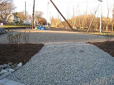
View up the Path to the Parking Lot
Photography by: Pawtuxet River Authority
Date of Photograph: November 22, 2008
The new parking lot at the start of the short path leading to the river.
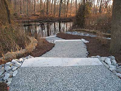
View Down the Path to the River
Photography by: Pawtuxet River Authority
Date of Photograph: November 22, 2008
View of the path leading from the parking area to the Pawtuxet River.
Do you have comments, corrections or additions to the information about this site?
Help us work together to make this website better by sharing your knowledge!


Private feedback goes to the Blueways Alliance/RI Land Trust Council. We'll use your information to make this website better or pass it along to the people who can deal with physical issues at this site. Public comments are posted here (once they've been reviewed and approved) for all to see.
The data on this website come from many sources, including volunteers and organizations across the state of Rhode Island and nearby parts of Massachusetts. We have done our best to make sure the data are accurate and up to date, but any information critical to the success of your trip should be confirmed before you start. The maps and information on this website should not be substituted for nautical charts, topographic maps, or other more detailed maps and guides. We welcome corrections and additions. To send a correction or provide other feedback, please use our feedback form (see link above).
This site report was last updated on June 14, 2026
Comments:
Closed
Submitted by: Bill; June 13, 2026; 4:41 pm
For some reason, the parking lot entrance is closed with sandbags.
Rating: