


 Woonasquatucket Reservoir (east side)
41° 54.581' N 71° 32.529' W See this location in: Google Maps Map Server Acme Maps
This is a site for launching hand-carried boats and it is also a portage. This typically means that to continue paddling down the river past this site you will have to portage your boat around a dam or other obstruction.
Description & Overview:
This access site is at the dam that creates Woonasquatucket Reservoir. There is also access to the reservoir on the west side, where there is a boat ramp. The shoreline there is also better for launching hand carried boats.
Woonasquatucket Reservoir is a 300-acre reservoir on the Woonasquatucket River. It is sometimes called Stillwater Reservoir and also Stump Pond from the days, now long past, when there were standing dead trees in the water from when the land was flooded to make the reservoir. There are some houses near the shore, but overall the shoreline is surprisingly natural given its suburban setting. It is a large body of water so waves large enough to cause problems for canoes and kayaks can form on a windy day. At the north end of the reservoir is Mowry Conservation Area, a beautiful natural area that includes walking trails and a very scenic section of the Woonasquatucket River.
Portaging around the dam is relatively easy, at least until you get to the riverbank. Most of the portage is on mowed grass but the riverbank is protected with riprap, which is less than ideal for launching boats.
Below the dam the Woonasquatucket River flows in a narrow valley under the high arch of the Stillwater Viaduct and then on into Stillwater Pond. This is a peaceful paddle in slow moving and still water, however to get back you will have to paddle upstream back to the put-in. This should not be hard for a reasonably strong paddler, but will be more work than going downstream. Continuing downstream beyond Stillwater Pond is problematic at this time because it requires two very long portages in rapid succession. The right hand (western) of the two outflows from the dam that creates Stillwater Pond is steep and boulder-ridden and not recommended for paddling, and the eastern of the two outfalls is not accessible. So the first portage would get you around those outflows and into Capron Pond, which is paddleable but very small. Below Capron Pond the river flows under Capron Road and then under I-295. Both of these bridges are likely spots for deadly "strainers" and there is also a short, steep drop in the river as it enters the tunnels under I-295. So, to continue down river below Capron Pond you should portage from Carpon Pond to Georgiaville Pond using Capron Road and Stillwater Road. Advanced permission is required to put-in at Smith-Appleby House on Georgiaville Pond.
There is a 10hp limit on Woonasquatucket Reservoir. The dam at this access site is a very popular location for fishing.
This site provides access to the following water bodies in the Woonasquatucket River watershed: Woonasquatucket Reservoir (Stillwater Reservoir), Woonasquatucket River.
Location:
Alternate Site Name: Stillwater Reservoir (east side)
Town: Smithfield
Nearest Town Center: Smithfield
Driving Landmarks: On Farnum Pike, just north of the junction with Route 116 (George Washington Highway), look for a large parking lot on the west side of the road.
Access & Waters:
Water 'Features' At Site: dam, flatwater/slow moving river, lake/reservior
Note: Because one boat launch can access, say, both a lake and a river or both the upstream and downstream portions of a river, not all paddling trips at a given site will necessarily encounter all of the features listed.
Type of Access: Boat launch for hand carried boats
ADA Accessible Boat Launch? no
Shoreline: The access to the reservoir here is on the earthen dam just beyond the parking lot. There is a concrete ramp for launching hand carried boats. Below the dam, the shoreline of the river is rocky except in high water when the river floods out onto the grass, making for much easier access to the river.
Float/Dock: no
Approximate Length of Carry between Car Access and Water: 100 feet
Portage Length: 250 feet
Hours of Operation: Dawn to dusk
Parking:
Parking: yes: 50 spaces
Sources for More Information:
AMC Quiet Water Canoe Guide: 2nd Edition, page 181
Photographs:
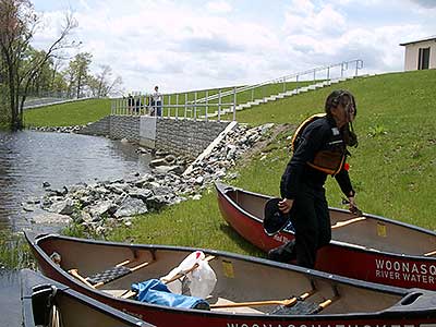
Boat ramp at Woonasquatucket Reservoir
Photography by: Bruce Hooke
Date of Photograph: June 20, 2006
This photograph shows the lower end of the boat ramp near the dam on Stump Pond (Woonasquatucket Reservoir). The ramp is about 50 feet from the parking lot. If there is much wind blowing from the west or southwest the waves can build up along this shore making this ramp difficult to use. The boat ramp on the west side of the reservoir is better under these conditions.
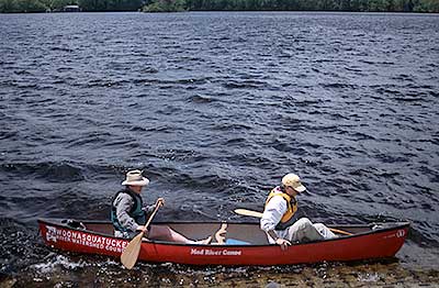
Below the dam at Woonasquatucket Reservoir
Photography by: John Monroe
Date of Photograph: June 20, 2006
This is a photograph of the access point to the river below the dam at Stump Pond. The water was high on the day this photograph was made. On a more typical day, there would be more rip-rap to cross to get to the river. The boat launch into the lake is about 200' away, on the other side of the dam.
Do you have comments, corrections or additions to the information about this site?
Help us work together to make this website better by sharing your knowledge!


Private feedback goes to the Blueways Alliance/RI Land Trust Council. We'll use your information to make this website better or pass it along to the people who can deal with physical issues at this site. Public comments are posted here (once they've been reviewed and approved) for all to see.
The data on this website come from many sources, including volunteers and organizations across the state of Rhode Island and nearby parts of Massachusetts. We have done our best to make sure the data are accurate and up to date, but any information critical to the success of your trip should be confirmed before you start. The maps and information on this website should not be substituted for nautical charts, topographic maps, or other more detailed maps and guides. We welcome corrections and additions. To send a correction or provide other feedback, please use our feedback form (see link above).
This site report was last updated on June 24, 2009
Comments:
Great Place
Submitted by: Albert; July 12, 2023; 1:21 pm
Love this Place I come here to Relax and Fish a Little,the View is Amazing ..
Rating:
Photographs:
Photo Credit: Albert