

 Marina Park
41° 25.624' N 71° 29.789' W See this location in: Google Maps Map Server Acme Maps
This is a site for launching boats from trailers. Boat ramps can normally be used to launch canoes and kayaks but please do your best to keep the boat ramp clear for boat trailers.
Description & Overview:

This is a very user-friendly launch facility in a small park called "Marina Park" at the head of Point Judith Pond. There are two cement plank boat ramps here. If the ramps are busy with trailered boats (as is common on a nice weekend) space can be a little tight for launching hand-carried boats, but you should be able to find some space. If the ramps are not too busy with trailered boats you can drive to the boat ramp area to load and unload, and then park across the street.
Paddlers can explore the pond or explore the lower Saugatucket River from here. Be mindful of the heavy pleasure boat traffic on the pond! Aside from the pleasure boat traffic, both the pond and the river are usually calm and easy to paddle.
The large grassy area next to the boat launch is the site for a number of annual events such as carnivals and boat shows. The URI sailing club is also in Marina Park.
On most days the southwest wind fills in across this area in the morning and blows throughout the afternoon, so be prepared for this when planning your trip.
The boat ramps were rebuilt in 2023 and there is no longer a drop-off at the end.
This site provides access to the following water bodies in the Saugatucket River watershed: Point Judith Pond, Saugatucket River.
Location:
Town: South Kingstown
Nearest Town Center: Wakefield
Driving Landmarks: From Route 1 North, take the Salt Pond Road exit. At the bottom of the ramp, turn right. The launch is 1/4 mile ahead on the left. From Route 1 south, take the South County Hospital/Salt Pond Road exit. At the end of the ramp turn left on Salt Pond Rd. The boat launch is 0.4 miles ahead on the left.
Access & Waters:
Water 'Features' At Site: estuary
Note: Because one boat launch can access, say, both a lake and a river or both the upstream and downstream portions of a river, not all paddling trips at a given site will necessarily encounter all of the features listed.
Type of Access: Boat ramp
ADA Accessible Boat Launch? yes
Shoreline: Paved, ADA accessible boat ramp. Adjacent shoreline is stabilized.
Float/Dock: low float or dock
Hours of Operation: sunrise to sunset
Fees: no
Limited to Town Residents? no
Parking:
Parking: yes: 100 spaces, overnight parking permitted
ADA Accessible Parking Spaces? yes
Nearby Amenities:
Public Restrooms: No
Sources for More Information:
Other Guidebooks: Salt Ponds Coalition Kayaker's Guide
Website: Salt Ponds Coalition Kayaker's Guide to the Coastal Salt Ponds of South County, RI
Website: Daytrippers Guide to Rhode Island
Photographs:
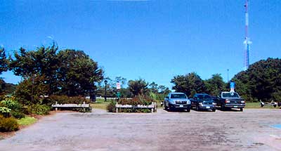
The parking lot at Marina Park
Photography by: Art Ganz and Bambi Poppick
Date of Photograph: August 17, 2006
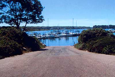
Boat Ramp at Marina Park
Photography by: Art Ganz and Bambi Poppick
Date of Photograph: August 17, 2006
Do you have comments, corrections or additions to the information about this site?
Help us work together to make this website better by sharing your knowledge!

Private feedback goes to the Blueways Alliance/RI Land Trust Council. We'll use your information to make this website better or pass it along to the people who can deal with physical issues at this site. Public comments are posted here (once they've been reviewed and approved) for all to see.
The data on this website come from many sources, including volunteers and organizations across the state of Rhode Island and nearby parts of Massachusetts. We have done our best to make sure the data are accurate and up to date, but any information critical to the success of your trip should be confirmed before you start. The maps and information on this website should not be substituted for nautical charts, topographic maps, or other more detailed maps and guides. We welcome corrections and additions. To send a correction or provide other feedback, please use our feedback form (see link above).
This site report was last updated on August 6, 2024